Water Quality/Marine and Estuary
- This article is about the topic of Water Quality for the 2020 and 2021 seasons. For information about the event in general, see Water Quality.
Marine and Estuary is the topic of Water Quality for the 2020 and 2021 seasons.
Overview
During the 2020 and 2021 seasons, this event will focus on areas such as: aquatic ecology, water cycle, nutrient cycling, aquatic chemistry and its implications for life, potable water treatment, waste water treatment, aquatic food chains/webs, community interactions, population dynamics, watershed resource management issues, sedimentation pollution, harmful species and recently killed coral.
Coral Reefs
General Information
Coral is a general term for different groups/types of cnidarians (jellyfish are also cnidarians!) or aquatic invertebrate animals. Coral organisms are called polyps and are associated primarily with limestone communities they create called “coral reefs”.
The coral polyp community share the same digestive and nervous system. Coral have a symbiotic relationship with a type of algae named zooxanthellae. The zooxanthellae perform photosynthesis for the coral and are one of the main sources of the coral’s food (up to 90%). Reproduction occurs both sexually and asexually. Many reefs reproduce as a mass spawn in which many of the coral species all release egg and sperm at the same time to externally fertilize. Once sperm and egg join, they form planktonic larvae that float in the currents up to the the surface (because light comes from the surface) before going back downwards and settling there if the conditions are right.
The coral colony shares a common digestive and nervous system. It has a limestone skeleton called a “calice” made of calcium carbonate (CaCO3).
Types of Coral Reefs
Charles Darwin proposed that, as extinct volcanoes subside, coral reefs progress from fringing to barrier to atoll.
Fringing Reefs
Most common reef, found along coastlines and islands/continents. Grows from the shore out toward the sea. Separated by shallow lagoon from mainland.
Barrier Reefs
Similar to fringing reef; also found along coastlines and islands, but lagoon is wider and deeper.
Atolls
Rings of coral with a lagoon in the middle usually found near the middle of the sea. Stage after fringing reef. Occurs once island has submerged.
Patch Reefs
Small and isolated reef usually found growing near the continental shelf (between fringing and barrier reef). Size varies from reef to reef.
Threats to Coral Reefs
Coral Bleaching
Primarily caused because of global warming (rising ocean temperatures and acidity). These conditions cause coral to become stressed and release their zooxanthellae (primary food source and also source of color/pigment). This leaves the coral without a major food source and discolored (“bleached”).
Blast Fishing
Importance of Coral Reefs
Coral reefs generate billions dollars in tourism yearly. They also shelter millions of different species, including many endangered species. Coral reefs have also been made an interesting point of study for the medical community. They support some new medical treatments. Coasts are sheltered from storms and erosion by coral reefs.
Interaction with Reef Organisms
Coralline algae deposit calcium carbonate for the coral polyps to use, resist wave erosion, and cement together sediments (typically coarse).
Important/Prominent Coral Reefs
Great Barrier Reef, Australia:
Consists of about 3000 different coral reefs and 900 islands that stretch out over 2300 kilometers and stretch about 344,400 square kilometers. Located on northeast Australia coast.
Estuaries
General Information
Estuaries are bodies of water where saltwater meets freshwater. Many plants and animals thrive because of the nutrient output. Estuaries provide a habitat for many different animals because of the output of nutrients, varying salinity and habitats, and high biological productivity. Habitats in estuaries include shallow waters, open waters, marshes and wetlands, sandy beaches, mud flats and oyster reefs.
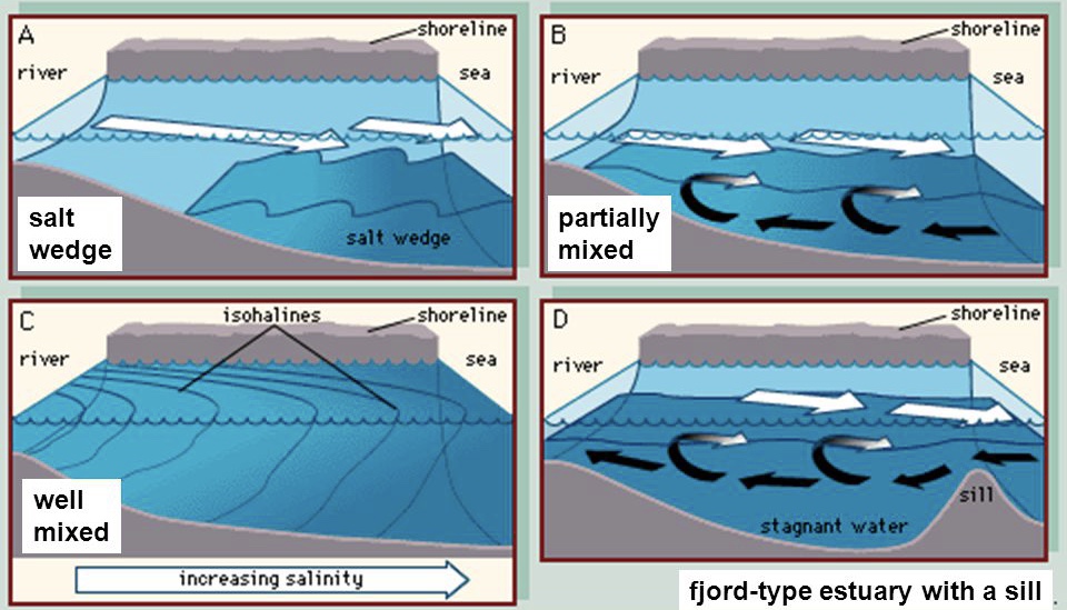
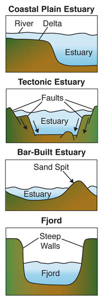
More names for estuaries include sounds, bays, harbors, lagoons, inlets. estuaries are classified by salinity (distribution) and geography. The types of salinity estuaries include: well mixed, partially mixed, salt wedge, and inverse (see diagram). The types of estuaries classified by geography include: coastal plain estuary, bar built estuary, fjord estuaries, tectonic estuaries. Estuaries are one of each classification of estuary (i.e. Chesapeake Bay, the largest estuary in the US, is a coastal plain sand salt wedge estuary.
An important plant found in estuaries is the mangrove tree. They form high density forests called mangles and hold sand together on the shore (preventing erosion).
Estuary Classifications
By circulation:
- salt-wedge: "wedge" of seawater fighting against strong river current
- slightly-stratified: isohalines form S shapes; stronger tides than salt-wedge, but weaker than well-mixed
- well-mixed: isohalines are vertical; strong tides
- fjord: a sill at the bottom prevents the bottom, anoxic, freshwater layer from mixing
By geography
- coastal plain/drowned river valley/ria: what used to be a river mouth became an estuary as rising sea levels "drowned" the mouth
- tectonic: tectonic plate movement causes a large piece of land to subside or sink, which then receives fresh and salt water input
- bar-built: wave action deposits sediments in front of the estuary in the shape of a bar, protecting it from waves
- fjord: U-shaped valley carved by glaciers
Important/Prominent Estuaries
Chesapeake Bay:
Largest estuary in the US; about 6400 square miles. Crosses through six states (Virginia, Maryland, Delaware, West Virginia, Pennsylvania, New York) and Washington, D.C.
Puget Sound:
Fjord estuary located in Washington near Seattle and Tacoma.
San Francisco Bay:
A tectonic estuary located in California. Created due to the tectonic activity in the surrounding Californian area.
St. Lawrence Estuary:
The world’s largest estuary; located where the St. Lawrence river reaches the ocean. This estuary is mostly located in Canada. The river has a length of over 1,900 sq. miles and then watershed for the river is over 390,000 sq. miles. For comparison, the largest estuary in the US (Chesapeake Bay) has a watershed of about 64,000 sq. miles. 5 Canadian provinces border the St. Lawrence gulf.
Wastewater Treatment
For information on Wastewater Treatment, please see Water Quality (main Water Quality page).
Information covered on the main water quality page includes the main steps in wastewater treatment and three parts/stages of wastewater treatment. Some works cited on this page may have provided information for that information, as some of that information was first on this page.
Ecology
For information on Ecology, please see Ecology and/or Water Quality.
Information covered on the main water quality page includes species interactions, survivorship curves, r/K speciation, and environments. Some works cited on this page may relate to that information, as some of that information was first on this page.
Oceans
5 main oceans: Pacific Ocean, Atlantic Ocean, Indian Ocean, Arctic Ocean, and Southern/Antarctic Ocean. Most common ions are: NaCl (composes 85% of seawater) and MgSO4 (composes about 4%). In the ocean, the ratio of the ions are always constant; salinity might change, but the ratio of ions to each other are always constant.
Oceans Information/Statistics
Area:
Pacific Ocean: 166.2m km2, 64.2m mi2. Atlantic Ocean: 86.5m km2, 33.4m mi2. Indian Ocean: 73.4m km2, 28.3m mi2. Arctic Ocean: 9.5m km2, 3.7m mi2.
Average Depth:
Pacific Ocean: 4188 m, 13741 ft. Atlantic Ocean: 3736 m, 12258 ft. Indian Ocean 3872m , 12704 ft. Arctic Ocean: 1330 m, 4364 ft.
Deepest Point:
Pacific Ocean: Mariana Trench/Challenger Deep; 11022 m, 36163 ft. Atlantic Ocean: Puerto Rico Trench; 8605 m, 28233 ft. Indian Ocean: Java Trench; 7725 m, 25344 ft. Arctic Ocean: Molloy Deep; 5608 m, 18400 ft.
Animals/Organisms
Main 3 types are sessile, benthic, and plankton.
Sessile: Sessile organisms are attached to one place (i.e. abalone). Benthic: Benthic/Benthos organisms live on the bottom of the water column; in sediment, on rocks, or crawl on seafloor. These organisms are useful because they are sensitive to some water quality aspects changes such as turbidity and oxygen. this makes them a good indicator species. Nekton: Nekton are animals that can swim well. Most nekton are vertebrates and can be pelagic, but are not all pelagic or vertebrates. Plankton: Pelagic organisms that don’t swim well; generally they drift rather than swim. Euryhaline: Species that can withstand a large range of changes in salinity.
Gyres and Garbage Patches
In all five major ocean gyres, there is a garbage patch. Five ocean gyres/garbage patches: North Atlantic, South Atlantic, North Pacific, South Pacific, Indian Ocean. All gyres have a significant impact on the ocean; they drive the oceanic conveyor belt. Great Pacific garbage patch is located between Hawaii and California. Most plastics are micro plastics; they are smaller than the eye can see but have a major effect on the ocean.
Coriolis Effect
The Coriolis effect is an effect caused by earth’s rotation. For example, a missile shot from the North Pole to New York will not land in New York. If it takes an hour to get to New York, then it will be where New York was an hour ago. The Earth rotated, causing the missile to hit some other sad town instead. This is one of the most obvious effects of the Coriolis effect, but there are some other important effects. Currents run in opposite directions in the North to South hemispheres. Since currents move to the left in the Southern Hemisphere, storm systems run clockwise. In the Northern Hemisphere, the opposite is true.
The Coriolis effect is also found on other planets. Earth rotates slowly compared to other planets, so the fact of it’s Coriolis effect is not as large. (everything after this is not typically tested on at all; it is just for the fun of learning the subject!) On the other hand, Jupiter rotates the fastest out of all the planets, causing north-south winds to be transformed into east-west winds (some travelling more than 680 mph!!). Divisions between winds create “belts” and between the belts are boundaries with string storms. One well known storm boundary is the Great Red Spot, a storm 180 years old!
Waves
Ocean waves are caused by wind, which is caused by the sun. In a wave (within a perfect setting), the water is not moved closer to or farther away from shore; it is just moved in a circular motion.
Parts of Waves:
Crest: Highest part of wave. Trough: Lowest part of wave. Height: Distance between crest and trough. Wavelength: distance between waves. Period: time it takes for one wave to pass. Fetch: The distance a wave has traveled. Celerity: Wave speed.
Tides
Tides are caused by the gravitational pull of the moon and centrifugal force. A full tide cycle takes 14 hours and 50 minutes, the 50 minutes being for the earth to catch up with the moon.
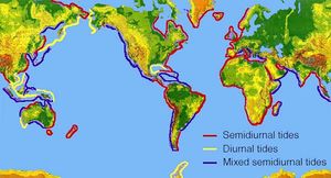
Diurnal Tides
Only one high and one low tide per day. (Least common).
Semidiurnal Tides
Two high tides and two low tides each day.
Mixed Semidiurnal Tides
Two high tides and two low tides each days of differing sizes.
Neap Tides
These are the low peaks of the tides, occurring during first and third quarters.
Spring Tides
Derived from the term to “spring forward”, this is when the tides are at their peak. They occur during full and new moons.
Marine and Estuary Rotation Organisms
- Main article: Water Quality/Marine and Estuary Macroorganism List
External Links
- https://www.chesapeakebay.net/discover/ecosystem/the_estuary_system
- https://www.nationalgeographic.org/encyclopedia/estuary/
- https://oceanservice.noaa.gov/education/tutorial_corals/coral06_reproduction.html
- https://oceanservice.noaa.gov/facts/threecorals.html
- https://www.vocabulary.com/lists/302508
- https://www.wsfcs.k12.nc.us/cms/lib/nc01001395/centricity/moduleinstance/17938/2_-_ecology.doc
- https://www.britannica.com/technology/wastewater-treatment/Primary-treatment
- https://www.usgs.gov/special-topic/water-science-school/science/adhesion-and-cohesion-water?qt-science_center_objects=0#qt-science_center_objects
- https://www.usgs.gov/special-topic/water-science-school/science/water-universal-solvent?qt-science_center_objects=0#qt-science_center_objects
- https://en.wikipedia.org/wiki/Capillary_action
- https://www.enotes.com/homework-help/what-is-the-biggest-estuary-world-555254
- https://www.canoncity.org/180/Water-Treatment-Plant-Process
- https://en.wikipedia.org/wiki/Backwashing_(water_treatment)
- https://sites.google.com/site/mrsromanshonorsbiology/assignments/survivorshipcurvehw (image)
- https://en.wikipedia.org/wiki/R/K_selection_theory
- https://www.nationalgeographic.org/encyclopedia/coriolis-effect/
- https://slideplayer.com/slide/4742878/ (image)
- http://www.hurricanescience.org/science/basic/tides/ (image)
- https://oceanservice.noaa.gov/facts/springtide.html
- https://geo.libretexts.org/Bookshelves/Oceanography/Book%3A_Oceanography_(Hill)/09%3A_Coastal_Processes/9.1%3A_Estuaries (image)
- https://slideplayer.com/slide/4742878/ (image)
- https://www.soinc.org/sites/default/files/uploaded_files/2020_WQ_MARINE_ESTUARY_071719.ppsx (download)


