Severe Storms/Thunderstorms
This page is incomplete. |
This page is to be used for the Severe Storms topic of the Meteorology event.
Thunderstorms
Air Mass Thunderstorms
In the United States, Air Mass Thunderstorms frequently occur when maritime tropical (mT) air moves northward from the Gulf of Mexico. These warm, humid air masses contain abundant moisture in their lower levels and can be unstable when heated from below or lifted along a front.
Life Cycles of Thunderstorms
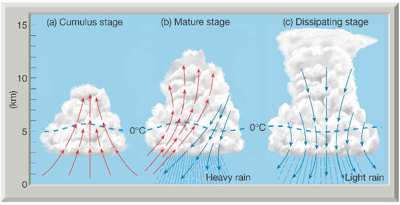
For the average thunderstorm there are three stages:
The Cumulus
The Cumulus stage is dominated by rising currents of air (updrafts) and the formation of a towering cumulonimbus cloud. Falling precipitation within the cloud causes drag on the air and initiates a downdraft that is further aided by the influx of cool, dry air surrounding the cloud, a process termed entrainment. This stage then progresses to the mature stage. Cloud for the thunderstorm begins to form and grow due to updraft, the rising updraft of air begins to cool and condense and can travel tens of thousands of feet before stopping, requires a constant supply of moist air, latent heat allows it to rise progressively, as the raindrops are large and heavy enough to fall to the ground the second stage begins, no downdraft, just warm updraft
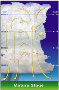
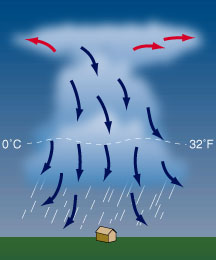
Mature Stage
The mature stage is marked by the downdraft leaving the base of the cloud and the release of precipitation. With gusty winds, lightning, heavy precipitation, and sometimes hail, the mature stage is the most active period of a thunderstorm. During the mature stage the downdraft(rain and cool air) begins to descend towards the surface, when the downdraft hits the ground it spreads in all directions which could form a gust front(separates rain cooled air from warm air), hail and the heaviest rain fall at this stage as long as the updraft is strong enough, downdraft eventually cuts of the updraft and begins the thirds stage
Dissipating Stage
Marking the end of the storm, the dissipating stage is dominated by downdrafts and entrainment. Without a supply of moisture from updrafts, the cloud soon evaporates. It should be noted that within a single air-mass thunderstorm there may be several individual cells—that is, zones of adjacent updrafts and downdrafts. This is the stage where the updraft is weak or non-existent, with only the downdraft left the t-storm slowly dies. In Severe t-storms this cycle is extended due to the differences in the inflow, if the updraft is slanted then the rain that falls will not impact the inflow of moist air allowing the t-storm to continue longer
Summary
So in summary here are all the stages together:
30/30 Rule
The 30-30 Rule is an easy way to determine the threat of lightning in your area: 30 Seconds: Count the seconds between seeing lightning and hearing thunder. If this time is less than 30 seconds, lightning is a threat. ... Even if you can't see the lightning, just hearing the thunder is a good backup rule.
Severe Thunderstorms
Severe Thunderstorms are capable of producing heavy downpours and flash flooding as well as strong, gusty straight-line winds, large hail, frequent lightning, and perhaps tornadoes.
For a thunderstorm to be officially classified as severe by the National Weather Service, it must have winds in excess of 93 kilometers (58 miles) per hour or produce hailstones with diameters larger than 1.0 inch or generate a tornado. Of the estimated 100,000 thunderstorms that occur annually in the United States, about 10 percent (10,000 storms) reach severe status.
Regular air-mass thunderstorms are localized, relatively short lived phenomena that dissipate after a brief, well-defined life cycle (above). The key factor for a severe thunderstorm is a strong vertical wind shear. That way the cold downdraft does not cut off the updrafts, which are the thunderstorm's "fuel".
Mesoscale Convective Complexes
A mesoscale convective complex (MCC) is a unique kind of mesoscale convective system which is defined by characteristics observed in infrared satellite imagery. They are long-lived, nocturnal in formation and commonly contain heavy rainfall, wind, hail, lightning and possibly tornadoes.
Types of Thunderstorms
Single Cell
Single cell thunderstorms, also known as pulse storms, usually last 20 to 30 minutes. Although severe weather is uncommon in single cell storms, heavy rainfall, downbursts, hail, and even weak tornadoes are possible. Single cell thunderstorms form in environments with low wind shear.
Multi-Cell Cluster
A multi-cell cluster storm is a group of cells moving as a single unit. Each constituent cell of a multi-cell cluster is at a different stage of thunderstorm development. New cells develop on the upwind side of the cluster, mature cells can be found in the center, and dissipating cells are on the downwind side. Alike single cells, multi-cell clusters can still produce heavy rainfall, downbursts, and hail, but the risk of flash flooding can be significant, and tornadoes are less likely.
Multi-Cell Line
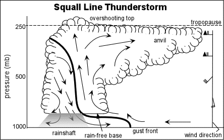
A squall line is a line of severe thunderstorms that can form along and/or ahead of a cold front. It contains heavy precipitation, hail, frequent lightning, strong straight line winds, and possibly tornadoes and waterspouts. Squall lines typically form in unstable atmospheric environments where low-level air can rise unaided after being initially lifted (e.g., by a front) to the point where condensation of water vapor occurs. Heat is released during condensation, resulting in the rising air becoming lighter than nearby air at the same height. This leads to an increase in the speed of the rising air which sometimes reaches speeds above 30 mph. In models this initial lifting is specified through an idealization of the flow associated with the front or other lifting mechanism or through the use of observational flow information. The gust front is located along the line where these winds meet -- which extends from the surface well up into the the storm.
Supercells
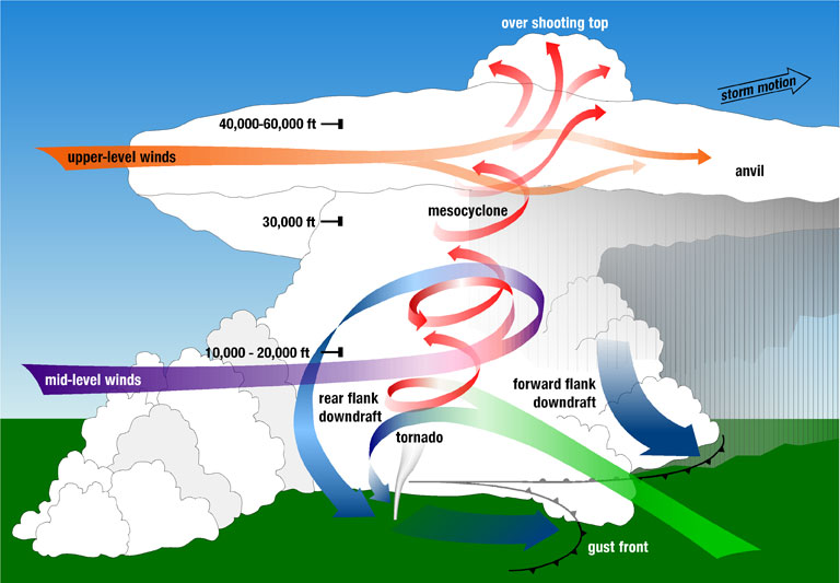
A supercell is a large rotating thunderstorm with a mesocyclone. They can last longer than normal thunderstorms and can produce tornadoes and baseball size hail.
Mesocyclones
A mesocyclone is a large rotating vortex of air. They rotate in the same direction as a low air pressure system would in the same hemisphere as the mesocyclone. They are formed when wind shear starts a portion of air in the lower atmosphere spinning in a tube like formation around a horizontal axis. The updraft found in a supercell can cause the "tube" to angle upwards until the air is rotating around a vertical axis.
Parts
- The overshooting top is a dome shaped formation on the top of a supercell caused by a very strong updraft lifting a portion of clouds above the anvil.
- The anvil is the overshooting portion at the top of the supercell. It is very cold and has almost no moisture in it.
- The precipitation free base is a portion of the supercell from which no precipitation is falling. Hail may be present, however.
- The wall cloud is the portion of the supercell between the precipitation free base and precipitating areas. It forms when cool air is pulled into the updraft. The air from this area quickly becomes completely saturated, and becomes visible as a cloud. The area of saturated air moves downward, so the wall cloud appears as a descending column. Very few of these turn into tornadoes.
- The rear flank downdraft is the downdraft on the back side of a supercell. It is dry air that wraps around the mesocyclone and is important to tornado development. After it descends to the ground, it moves east into the updraft.
- The forward flank downdraft is the downdraft on the leading side of a supercell. It is the main downdraft and the area with the heaviest precipitation.
- The flanking line is a line of cumulus clouds on the southwest side of the supercell. It forms along the rear flank downdraft.
- The gust front is the boundary between the updraft and downdraft of a thunderstorm. In supercells it is located between the updraft and the rear flank downdraft.
- The mesocyclone is the rotating updraft of a supercell.
Tornadoes
Tornado Characteristics
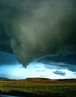
Tornadoes are large clouds mostly characterized by extremely high winds. They are usually found in the most intense supercells and are caused by winds traveling in different directions, or wind shear. They usually look like large funnels touching down from the main cloud. Note that although most tornadoes look like funnel clouds, they do not necessarily need to have one, as long as the winds touch both the ground and the cloud. Consequently, a funnel cloud may occur but not a tornado if the funnel does not touch down.
Geographical and Seasonal distribution
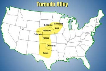
The United States are home to the largest amount of tornadoes. Most of them occur in a central region known as Tornado Alley, which contains the states of Texas, Oklahoma, Kansas, Nebraska, and the edges of other states, depending on the definition. However, tornadoes have been observed on every continent excluding Antarctica, and every state in the United States.
Meteorologist also now reference a 2nd "alley" referred to as "Dixie Alley." Dixie Alley includes states of the SE United States such as Missouri, Tennessee, Arkansas, Alabama and Mississippi. There is also a pattern with the time of year and the frequency of tornadoes. The majority of tornadoes form between April and mid-June.
Tornado Hazards
Much of the damage caused by a tornado can be related to the high winds, as this is the essence of a tornado. However, a lot of damage is also caused by the flying debris resulting from the destruction of some structures. Their impact can destroy other buildings more easily. Other hazards include downed power lines, broken gas lines and pumps, and fires.
The Fujita Scale
Two major scales measure tornadoes: the Fujita scale and the Enhanced Fujita Scale. Both measure from 0 to 5, but the characteristics of both are different.
The Fujita scale, or Fujita-Pearson Scale, is as follows.
| Scale | Wind Speed (mph) | Damage |
|---|---|---|
| F0 | 40-72 | Minor damage |
| F1 | 73-112 | Moderate damage |
| F2 | 113-157 | Considerable damage |
| F3 | 158-206 | Severe damage |
| F4 | 207-260 | Devastating damage |
| F5 | 261-318 | Incredible damage |
An F6 category was also thought of, but it is purely hypothetical and no F6 tornado has actually existed.
The Enhanced Fujita Scale was intended to improve the Fujita scale.
| Scale | Wind Speed (mph) | Damage |
|---|---|---|
| EF0 | 65-85 | Minor damage |
| EF1 | 86-110 | Moderate damage |
| EF2 | 111-135 | Considerable damage |
| EF3 | 136-165 | Severe damage |
| EF4 | 166-200 | Devastating damage |
| EF5 | >200 | Incredible damage |
Life Cycles of Tornadoes
Three stages usually categorize a tornado's life. Please note that although these are the most common, not all tornadoes follow this exact pattern and it is merely a model. Nevertheless, it is something you should know.
Formation
Most tornadoes are formed from a supercell thunderstorm, the most violent thunderstorm to exist, but there are specific conditions needed in order to create the tornado. First, the clouds are created as a byproduct of condensation. Condensation releases heat, which serves to become the energy that drives the updrafts of the thunderstorm. The more condensation there is, there will be bigger and stronger updrafts. Climbing higher and higher,the updrafts can suddenly change direction and move quicker. If the storm's base has a lot of moisture, there will be a cloud base that forms, which will give something for the tornado to feed off of later. Once all of these ingredients are set in place, a mesocyclone will develop. Outside of the mesocyclone, a mass of cool dry air wraps around it, known as a rear flanking downdraft. It creates a temperature difference between the air inside the mesocyclone and the air surrounding it, which helps create a level of instability so that the tornado will be able to thrive.If conditions are right, the rotation of winds within a mesocyclone allows a vortex to form underneath it, and a funnel cloud usually forms with this. Then the mesocyclone spins tighter which helps increases the speed of the tornado.It gains energy as it descends and it becomes a tornado once it touches the ground.
Maturity
Once the funnel cloud becomes a tornado, it enters its mature stage. This is where all the destruction comes in.
Dissipation
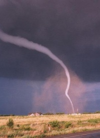
When the mesocyclone loses its rotation and/or conditions are no longer right for a tornado, it begins to dissipate. The shape of the tornado can be altered into a rope-like form or some other shape, depending on the characteristics of the storm it is in.
Waterspouts
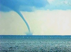
Waterspouts are similar vortexes that occur over water. They are usually less violent than regular tornadoes, although they can be rather powerful given a strong storm.
Winds
Straight Line Winds
Straight line winds are usually associated with thunderstorms or squall lines. These winds often splash out in all directions like when you throw a bucket of water on the ground. However, to someone on the ground at a single location, winds seem "straight line" because they're blowing in just one direction. This is different from tornado winds, which change direction over time at any given location as the tornado moves past.
Derechos
A derecho is a widespread, long-lived, straight-line wind storm that is associated with a fast-moving group of severe thunderstorms known as a mesoscale convective system & potentially rivaling hurricane & tornado forces. Derechos can cause hurricane-force winds, tornadoes, heavy rains, & flash floods. Derechos are divided into 3 types, Serial, Progressive, and are produced by multiple bow echoes embedded in an extensive squall line (often many hundreds of miles long) that sweeps across a very large area, both wide and long. Progressive Derechos mainly occur during summer time. These are associated with a relatively short line of thunderstorms; typically, 40-250 miles (65-400 kilometers) in length. Hybrid Derechos are a combination of the traits of a progressive derecho and a serial derecho
Katabatic Winds
These winds are caused by more dense air flowing downhill into less dense air. The more denser air at higher levels originates from being cooled by the ground, especially at night. These winds can occur in mountain valleys. They're particularly strong in Antarctica (Read More)
Downbursts
Micro and Macrobursts
A microburst is a small concentrated downburst that produces an outward burst of strong winds at or near the surface. Microbursts are small — less than 4 km across — and short-lived, lasting only five to 10 minutes, with maximum wind speeds sometimes exceeding 100 mph. There are two kinds of microbursts: wet and dry. A wet microburst is accompanied by heavy precipitation at the surface. Dry microbursts, common in places like the high plains and the intermountain west, occur with little or no precipitation reaching the ground. A macroburst is an outward burst of strong winds at or near the surface with horizontal dimensions larger than 4 km (2.5 mi) and occurs when a strong downdraft reaches the surface. To visualize this process, imagine the way water comes out of a faucet and hits the bottom of a sink. The column of water is the downdraft and the outward spray at the bottom of the sink is the macroburst. Macroburst winds may begin over a smaller area and then spread out over a wider area, sometimes producing damage similar to a tornado. Although usually associated with thunderstorms, macrobursts can occur with showers too weak to produce thunder.
Gust Fronts
A gust front is the leading edge of rain-cooled air that clashes with warmer thunderstorm inflow. Gust fronts are characterized by a wind shift, temperature drop, and gusty winds out ahead of a thunderstorm. Sometimes the winds push up the air above them, forming a shelf cloud or detached roll cloud.
Lightning
Causes of Lightning
A storm is only classified a a thunderstorm when there is lightning. Thus, its important to discuss the causes of lightning. Some cloud physicists believe that charge separation occurs during the formation of ice pellets. Experimentation shows that as droplets begin to freeze, positively charged ions are concentrated in the colder regions of the droplets, whereas negatively charged ions are concentrated in the warmer regions. Thus, as the droplets freeze from the outside in, they develop a positively charged ice shell and a negatively charged interior. As the interior begins to freeze, it expands and shatters the outside shell. The small positively charged ice fragments are carried upward by turbulence, and the relatively heavy droplets eventually carry their negative charge toward the cloud base. As a result, the upper part of the cloud is left with a positive charge, and the lower portion of the cloud maintains an overall negative charge with small positively charged pockets. As the cloud moves, the negatively charged cloud base alters the charge at the surface directly below by repelling negatively charged particles. Thus, the surface beneath the cloud acquires a net positive charge. These charge differences build to millions and even hundreds of millions of bolts before a lightning stroke acts to discharge the negative region of the cloud by striking the positive area of the ground below, or, more frequently, the positively charged portion of that cloud, or a nearby cloud.
How Lightning Strikes
Pop quiz: Does lightning start from the cloud and move down, or does it start from the ground and move up? The answer: Neither. This is because a lightning strike is not a single brilliant bolt, but actually several strokes. First, there is a stream of electrons that moves downwards from the cloud. This is called the initial leader(or Step leader). As it nears the ground, electrons are pulled from the surrounding air, resulting in a ionized path from the cloud to ground. Then, electrons pour from this channel of charge. This is the main stroke (or Return Streamer) and is what we think of "lightning".
Other Kinds of Lightning
Cloud lightning
Lightning does not always strike the ground. It can either occur between two separate clouds, or within the same cloud, which is the most common. When it occurs with in the same cloud, it will usually start in the lower portion of the anvil, and move downward.
Heat lightning
Heat lightning appears to produce no thunder. In fact, it does, but it happens so far away that the observer does not hear it, because the sound dissipates through the air.
Positive Lightning
Positive lightning occurs when there are little to no clouds. These lightning bolts originate from the top of a cloud, usually the anvil, and travels horizontally for several miles before turning and moving downward to meet the initial leader.
Ball Lightning
The entire existence of ball lightning can be disputed because of it's lack of observation. Ball lightning has been spotted hundreds of times around the world, but very rarely by meteorologists. Observers say that ball lightning appears as a sphere, differing in size from between a few inches in diameter to several meters, and varies in color between red, orange, yellow, even green or white. It can appear after a large thunderstorm. It travels mostly horizontally, from about waist high to several meters off the ground. Usually ball lightning comes with a bad smell. It can come in through open doors or windows, including closed screens, and sometimes chimneys. No ball lightning stays for more than a few seconds, and it moves at a brisk pace- several meters per second. Sometimes observers report that it will "bounce" between puddles.
Because even the existence of ball lightning can't be proven, not very much is known about it other than its appearance. As of right now, no theories have been suggested that can explain the strange movement, appearance, and how it can produce a constant stream of light and energy.
It is thought that UFO sightings after a large storm can actually be ball lightning. So the next time you see a ball of light high in the sky after a large storm, you may not be seeing a UFO, but instead a rare example of ball lightning.
Transient Luminous Events
While a majority of weather events occur in the troposphere, some short-lived phenomena can be seen in the upper atmosphere. These events are commonly referred to as transient luminous events (TLEs). While some sources may refer to TLEs as upper-atmospheric lightning, this term can come with some problems. Some TLEs are not true lightning and are instead forms of plasma, lacking many of the characteristics that normal lightning has. Most of these TLEs are very difficult to study due to their position in the atmosphere as well as the fact that many of them last for only a few milliseconds when they appear.
The most common TLE is a sprite, which is a bright red or orange flash of light which occurs above cumulonimbus clouds. Sprites are most commonly caused by cloud-to-ground (CG) lightning where positive lightning discharges between a thundercloud and the ground. A sprite may also be preceded by a faint flash known as a sprite halo. As opposed to normal tropospheric lightning, sprites are made up of cold plasma much like the discharge from a fluorescent tube.
Blue jets come out of the top of thunderclouds, and are much less frequent than sprites. They are not directly associated with CG lightning, and their cause is still unknown. It is believed that blue jets occur when lightning discharges between the upper positive region of a thundercloud and a negative region above the cloud, however.
Elves (Emission of Light and Very Low Frequency perturbations due to Electromagnetic Pulse Sources) are rapidly expanding glowing regions that typically only last for one millisecond. Elves are the result of electromagnetic pulses that extend into the ionosphere, one of the highest areas of Earth's atmosphere. They are typically associated with gamma ray flashes, and are red in color.
Effects
According to the National Weather Service, only 10% of people that are struck by lightning are killed, leaving the remaining 90% with various injuries If you get hit by lightning, it usually damages the nervous system. When the brain is affected, the person may have difficulty with short-term memory, coding new information and accessing old information, multitasking, and being easily distracted. Lightning victims may also suffer personality changes because of frontal lobe damage and become irritable and easy to anger. In addition, some survivors complain of becoming more easily exhausted than before being struck.
Haboobs
Haboob-a dust storm created when a thunderstorm's downdraft reaches the ground and moves outwards from the thunderstorm, creating the outflow boundary (also known as the gust front). As the downdraft hits the ground and spreads outwards, intense winds pick up loose sediments, creating what appears to be a wall of dust.
Dangers of Haboobs
The most eminent danger of haboobs is low visibility, dropping to virtually zero, which is very dangerous for motorists. Also, the sediments may trigger respiratory complications, such as asthma. Another potent threat are fungi spores, which cause fungal infections. The best way to stay safe in a haboob is prior to its arrival, get off roads and indoors. If caught outside, make a makeshift mask and cover your mouth and nose.
Special Topics for 2017
This section is incomplete. |
- Hurricane Patricia October 2015
- Eastern U.S. Blizzard January 2016
- Colorado Floods September 2013
- Tornado Outbreak February 23-24, 2016


