Meteorology/Everyday Weather
| Meteorology/Everyday Weather | |||||||
|---|---|---|---|---|---|---|---|
| Type | Earth Science | ||||||
| Category | Study | ||||||
| Event Information | |||||||
| Participants | Up to 2 | ||||||
| Approx. Time | Approx. 50 Minutes | ||||||
| Impound | No | ||||||
| Allowed Resources |
| ||||||
| Eye Protection | None | ||||||
| Latest Appearance | 2019 | ||||||
| Forum Threads | |||||||
| |||||||
| Question Marathon Threads | |||||||
| |||||||
| Additional Resources | |||||||
| Test Exchange | Link | ||||||
| Division B Results | |||||||
| |||||||
Meteorology is a weather and climate based event designed to test students' understanding of meteorological concepts. Its topic changes every year between Everyday Weather, Severe Storms, and Climate.
This subpage of Meteorology refers to its 2010, 2013, 2016, and 2019 topic. For a sample note sheet for this topic, see EpicFailOlympian's 2010 Everyday Weather Notes.
Topics for Everyday Weather
The Everyday Weather topic of Meteorology requires an understanding of how weather is described and measured, the physical factors affecting it, and how it can be predicted. Major topics for competition in Everyday Weather include:
- Structure and composition of the modern atmosphere
- Solar radiation and seasons
- Properties of water and its effect on weather
- Atmospheric moisture
- Types and forms of hydrometeors
- Atmospheric pressure
- Air masses and fronts
- Local winds and precipitation
- Non-severe, hazardous weather and storms
- Surface weather stations
- Upper-air charts
- Weather instruments and technology
- Weather forecasting
- Temperature indices
The Atmosphere
Earth's atmosphere is the collection of gases, along with suspended liquids and solids within those gases, that surround the surface of the Earth. The atmosphere is bound to Earth by gravity and its properties, such as composition, temperature, and pressure vary with location, altitude, and time. The atmosphere gets gradually less dense as altitude increases, with no strict boundary between it and outer space.
Atmospheric Composition
The gases in the atmosphere are often divided into two categories: permanent and variable gases.
Permanent gases are gases that are fairly uniform in concentration throughout the atmosphere and through time. They include nitrogen (N2), oxygen (O2), and argon (Ar). Nitrogen is the most abundant gas in the atmosphere (about 78% of the atmosphere by volume), followed by oxygen (about 21%), followed by argon (about 0.9%).
Variable gases are gases that are found at significantly different concentrations at different locations, altitudes, or times within the atmosphere. The most significant variable gas is water vapor (H2O), which is responsible for the formation of clouds and precipitation. Its concentration van be as high as around 4% in the tropics, to nearly zero in polar regions. Other variable gases include carbon dioxide (CO2) and ozone (O3).
Atmospheric Structure
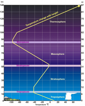
Meteorologists often organize the atmosphere into four layers according to how the average temperature of the atmosphere changes with altitude. These layers from the Earth's surface upwards are: the troposphere, the stratosphere, the mesosphere, and the thermosphere.
Troposphere
The troposphere is where the majority of weather on Earth takes place. It is a region of rising and falling pockets of air moving mostly vertically. Its height varies with seasons, latitudes, and weather, with the equator having the highest troposphere (12-16 km) and the poles the lowest (8km).
Stratosphere
The stratosphere is located above the troposphere, at a height of about 12 kilometers to 50 kilometers, separated by a thin layer called the tropopause. The stratosphere is stratified in temperature, with the warmer layers higher and the cooler layers lower, with temperature increasing with height. This contrasts with the troposphere, in which temperature decreases with increasing height. Airplanes fly into the lower levels of the stratosphere above the clouds, as the stratosphere is less turbulent and more stable than the troposphere. Most clouds cannot form in the stratosphere because its temperature inversion inhibits convection. As a result, airflow in the stratosphere is mostly horizontal. The pressure in the stratosphere is only one thousandth of that at sea level.
The stratosphere also contains the ozone layer, which absorbs the majority of the dangerous ultraviolet (UV) radiation emitted by the sun. This is also the cause of the stratosphere temperature inversion, because the ozone layer is warming from absorbing the UV radiation.
Mesosphere
Above the stratosphere is the mesosphere, located between 50 kilometers and 80 kilometers. The mesosphere consists of extremely rarified air. It is the least studied layer of the atmosphere. In the mesosphere, temperature drops with increasing altitude, like in the troposphere. This is the layer that meteors disintegrate in due to collisions with gas molecules.
Thermosphere
The thermosphere is located between 80 kilometers and 700 kilometers, above the mesosphere. It is the outermost layer, excluding the exosphere, which extends further beyond the thermosphere. Though the thermosphere has a very high temperature, with temperatures up to 2500 degrees Celsius, due to the extremely fast movement of the gas molecules, it has a very low thermal energy because the molecules are spaced so far apart, and so a section of space in the thermosphere would contain very few molecules. (Remember that temperature is the average kinetic energy of each molecule, while thermal energy is total kinetic energy. Neither is it to be confused with heat, which refers to the transfer of thermal energy from a hotter object to a cooler one.)
It is important to know how temperature changes within each layer. (See the diagram on the right for reference)
Atmospheric Circulation
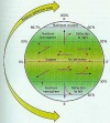
A non-spinning planet with no axial tilt would only experience the influence of unequal heating by the Sun, with the most direct sunlight reaching the tropics and the least amount reaching the polar regions. Under these circumstances, a simple convection system would suffice with extreme heating in the low latitudes causing warm air to rise.
When this rising air mass reaches the top of the tropopause, it stops its upward movement and begins to move towards the poles as an upper-level wind. Cooling air at the Polar Regions encourages the air to sink downward and fall towards the surface. At the surface, this cold air then begins to flow towards the equator.
These convection cells transfer heat by moving air from the equator towards the poles, and then cycling air near from the surface to the equator, forming the basis of the two cell model, as depicted on the right.
Air Pressure
Atmospheric pressure is the weight of the overlying column of air. As altitude increases, the amount of overlying air in the atmosphere, and therefore the pressure, decreases.
Around 80% of the mass of Earth’s atmosphere is located within the closest 18 kilometers to its surface, in the troposphere. This is because the air itself is also affected by air pressure; the higher air pressures at lower altitudes closer to sea level cause the air to be more compressed than at high elevations.
Atmospheric pressure is normally measured in units called millibars (mb). One millibar is equal to 1 gram per centimeter squared (1g/cm2). At sea level, the average air pressure is around 1,013mb. At the top of Mt. Everest however, the air pressure can get as low as 300mb. Although the concentration remains the same, the amount of oxygen in the atmosphere is decreased at higher elevations because of the lower air pressure, as the pressure of gases such as oxygen is related to density. That means there is only about 1/3 as much oxygen on Mt. Everest as there is at sea level, thus, many people who attempt to climb Mt. Everest experience shortness of breath as they climb to higher elevations.
Descending air forms high-pressure centers, or divergence. Polar highs result from the descent of cold air and its movement towards onto the surface. Subtropical highs form as warm air in the 20-30° latitude range in both hemispheres rises and then begins to cool as it falls towards the surface. This air is very dry making surface conditions in these regions very arid. Most of the world’s deserts in both hemispheres are found in this latitude range. High-pressure cells move in a clockwise direction in the Northern Hemisphere.
Ascending air forms low-pressure systems or areas of convergence. Tropical lows form as warm air ascends into the atmosphere. Subpolar lows form as warm air in the 50-60° latitude ranges of both hemispheres rises producing abundant precipitation. Low-pressure cells move in a counterclockwise direction in the Northern Hemisphere.
Air tends to move from areas of high to low pressure. Air is denser in high-pressure cells (anticyclones), which tend to be hot and dry: this is because air tends to heat up when compressed (adiabatic warming), evaporating clouds and leading to drier weather. The evaporation of clouds also decreases surface albedo (reflectivity). Low-pressure cells tend to bring precipitation because they draw air upwards, and the reduced pressure and temperature at higher altitudes cause water vapor to condense into clouds. Low-pressure areas (or cyclones) are often formed by the evaporation of warm, moist air over oceans.
Coriolis Effect and the Three Cell Model
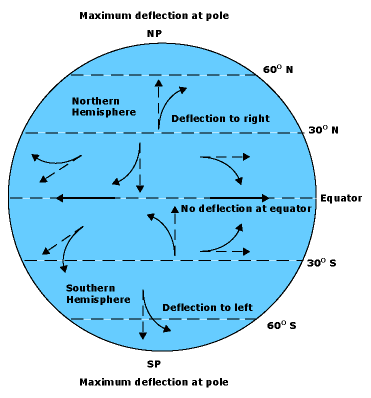
If the Earth did not rotate on its axis, there would be a single circulation cell in each hemisphere. The rotation of the earth on its axis from west to east creates the Coriolis Effect, which causes the different air masses created by the unequal heating of the planet’s surface to shift direction like the picture on the right (click on it to get a better view). Notice the deflection created by the Coriolis Effect and how it changes in each hemisphere and in different regions of each hemisphere.
The Coriolis Effect causes wind patterns in the Northern Hemisphere to differ from wind patterns in the Southern Hemisphere. In the Northern Hemisphere, the Coriolis Effect deflects the movement of air to the right. In the Southern Hemisphere, this movement is deflected to the left. This creates the three main wind belts found at the surface of each hemisphere including the easterly trade winds, prevailing westerlies and the polar easterlies.
Three Cell Model
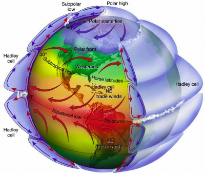
The Coriolis Effect turns the high and low pressure cells of each hemisphere into a series of three different convection cells known as the Hadley Cell, the Ferrel Cell, and the Polar Cell. All three cells are found in both hemispheres.
The three cell model shows the Earth's global winds and the global circulation of air in the form of convection cells, which are separated by pressure belts.
- The polar high is found at the poles, which are also the center of the polar cells, and therefore the Polar Easterlies.
- The Polar Cell which is the cold high-pressure cell around the poles. The winds in this cell blow like as expected with the Coriolis Effect, creating the Polar Easterlies.
- In between the Polar Cell and the next cell (Ferrel) there is a subpolar low.
- The Ferrel Cell is the mid latitude cell and is a warm cell, and also contains the Prevailing Westerlies.
- In between the Ferrel Cell and next cell (Hadley) there is a subtropical high.
- The Hadley Cell is also a warm cell and the winds again blow as expected with the Coriolis Effect, creating the Northeast Trade Winds in the Northern Hemisphere and the Southeast Trade Winds in the Southern Hemisphere.
The Real World
The real world screws up the concept of the Coriolis Effect. Take this picture for example:
As shown, some of the winds seem to be blowing in the "wrong" direction according to the Coriolis effect. This happens as winds blow from high pressure to low pressure. There is a subtropical high at 30 degrees and a sub polar low at 60 degrees, therefore the wind blows from 30 degrees to 60 degrees. That wind is still subject to the Coriolis Effect, therefore it still curves, it is just affected differently.
Local Wind Patterns/Global Winds
Planetary Winds
Global scale winds are winds that are created in the different Global circulation Cells.
- Polar Easterlies: blow from the poles to 60˚ latitude.
- Prevailing Westerlies: blow from 60˚ to 30˚ latitude.
- Trade Winds: blow from 30˚ latitude to the equator.
Mountain/Valley Winds
During the day, mountains warm, causing the air over them to be warmer than the air over the valley at the same elevation. Warming the air causes it to rise, creating a valley wind. During the evening, the air cools due to a loss of surface energy to space. The cool dense air moves down slope as a mountain wind.
Chinook Winds
A chinook wind is a warm dry wind on the leeward side of a mountain. As air descends the leeward side of a mountain (also known as the "Rain Shadow"), it is compressed and adiabatically heated. Warming the air causes the saturation point to increase, causing a decrease in its relative humidity. The new warm and dry wind move down slope rapidly, and during the spring causes substantial melting of mountain snow. A Chinook is a foehn wind that is specific to the Rocky Mountains.
Santa Ana Winds
Santa Ana winds are warm and dry winds. Over plateau regions in the desert region of the United States, high pressure pushes the air off the plateaus, forcing the air into narrow mountain valleys. As the air is forced through the valley it compresses and warms. As the air warms the saturation point rises and its relative humidity drops. These winds are often responsible for the dry conditions and fanning wildfires in Southern California
Heat Transport
Earth Energy Budget
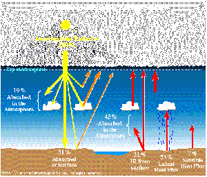
The Earth’s energy budget is determined by the amount of incoming energy and the amount of outgoing energy. Nearly all of Earth’s incoming energy (99.98%) is from solar radiation. The other 2% mostly comes from geothermal energy created by the radioactive decay of uranium and thorium in the Earth’s core. A very small amount, about .002%, of Earth’s incoming energy comes from the action of tides caused by the interaction of Earth with the Sun and Moon. Waste heat energy from fossil fuel consumption accounts for another .007% of Earth’s Energy Budget.
The Earth has an average albedo of approximately 30%, which means about 30% of incoming solar radiation is reflected back into space before it reaches Earth's surface. The atmosphere then absorbs 19% and the Earth’s surface absorbs 51%. Around 70% of solar energy that is absorbed by the Earth is then re-radiated as infrared energy. The Earth’s energy budget is in equilibrium as the amount of incoming energy is balanced by the same amount of outgoing energy.
Convection
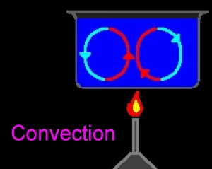
Convection is the transfer of heat from the Earth’s surface into the atmosphere. When a layer of air receives enough heat, it expands and is pushed upward by buoyancy. Then the air becomes more dense and moves laterally until it begins to sink and then rise again as it warms. Atmospheric convection currents are partly responsible for breezes, winds, cyclones and thunderstorms.
Radiation Budget
The radiation budget refers to the balance between the incoming shortwave radiation from the Sun and the outgoing longwave, or thermal, radiation that is reflected from Earth. Globally, this budget is balanced as the amount of incoming solar radiation is transformed into latent heat, or even kinetic energy. Energy transfers in the oceans along with the atmosphere keep the radiation budget in balance.
But locally, the Radiation Budget not balanced as tropical regions retain more insolation, while higher latitudes retain less. This accounts for differences in the temperature and pressure of air masses that originate in both regions affecting weather throughout the entire planet.
Air Masses and Fronts
Air Masses
Large bodies of air that pass slowly over large areas of Earth’s surface and they take on the characteristics of that region such as temperature and humidity. The area from which the air mass derives its characteristics is its source region.
Air mass source regions can be snow covered areas near the poles, arid deserts, or even tropical oceans.
Air masses that form over the ocean are termed maritime air masses. Those that form over land are called continental air masses. Any further classification of air masses are normally based on longitude, i.e. tropical air masses are formed in low latitudes, and polar are formed in high latitudes.
Classifications
| Air Mass | Description |
|---|---|
| Continental Tropical (cT) | Formed over land at low latitudes transports warm, dry air |
| Maritime Tropical (mT) | Formed over sea at low latitudes transports warm, wet air |
| Continental Polar (cP) | Formed over land at high latitudes transports cold, dry air |
| Maritime Polar (mP) | Formed over water at high latitudes transports cold, wet air |
The major air masses that influence the United States are:
- Polar air masses that form over Canada and Alaska often affect the weather of the United States as they move south and eastward.
- The states along the Gulf of Mexico and the Eastern seaboard often experience the effects of tropical air masses that move northward causing humid subtropical and continental climates.
- Occasionally, continental arctic (cA) air masses may descend from high latitude regions in the winter months creating bitterly cold weather.
Tropical air masses from the Pacific may affect California and the Southwestern states during the winter months. Although it is influenced by these major air masses, the United States itself is not a favorable source region for fronts because so many weather disturbances disrupt opportunities for the formation of air masses.
Air masses move from their source region due to the Coriolis Effect where they will meet adjacent air masses with different properties. When these two air masses of different origin meet, the boundary between them is termed a front.
Fronts
Frontal boundaries are very narrow, less than 200km wide. Normally one air mass is cooler than the other, giving the warmer air a tendency to flow up and over the cooler air mass. This cooler and denser air acts as a wedge that allows warmer less dense air to rise over it.
Types
There are five types of fronts, each with their own characteristics.
- Warm Front
- Cold Front
- Stationary Front
- Occluded Front
- Dry Line
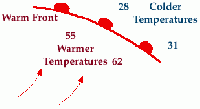
Warm Fronts
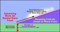
A warm front is when warm air moves in and displaces an area of once cooler air. Warm fronts are characterized by an increase in temperature and the appearance of cirrus clouds.
- Shown on a map as semicircles
- Clouds become lower as front nears
- Slow rate of advance
- Light to moderate precipitation
- Gradual temperature increase
| Before Passing | While Passing | After Passing | |
| Winds | South-southeast | Variable | South-southwest |
| Temperature | Cool-cold, slow warming | Steady rise | Warmer- then steady |
| Pressure | Usually falling | Levels off | Slight rise-then falling |
| Clouds | In this order Ci, Cs, As, Ns, St and fog | Stratus | Clearing with scattered Sc; some Cb in summer |
| Precipitation | Light to moderate rain, drizzle, snow or sleet | Drizzle or none | Usually none; possible light rain |
| Visibility | Poor | Poor- but improving | Fair in haze |
| Dewpoint | Steady rise | Steady | Rise, then steady |
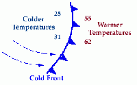
Cold Fronts
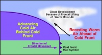
Cold fronts are formed when cooler air replaces an area that was once occupied by warmer air. They are associated with turbulent changes in weather. Temperatures drop as warm air is pushed aside vertically and abruptly. Tall, cumulonimbus clouds take shape and may form thunderstorms.
- Shown on a map as triangles
- Cold air replaces warm air
- Weather is more violent than warm front
- Faster rate of advance
- Intense precipitation
- Clear after front passes
| Before Passing | While Passing | After is passes | |
|---|---|---|---|
| Winds | South Southwest | Gusty and changing | West Northwest-ish |
| Temperature | Warm | Sudden drop | Steadily dropping |
| Pressure | Falling steadily | Minimum-then sharp rise | |
| Clouds | Increasing Ci, Cs and Cb | Cb | Clearing with scattered Sc; some Cb in summer |
| Precipitation | Short period of showers | Heavy rain, thunder, lightning, hail | Showers, then clearing |
| Visibility | Fair to poor | Poor followed by improving | Good-possible showers |
| Dewpoint | High, remains steady | Sharp drop | Lowering |
Stationary Fronts
Nearby stationary fronts bring weather patterns that may persist for days.
- Shown on a map as alternating triangles and semicircles facing in opposite directions
- Air flow parallel on both sides
- Doesn't move
- Widespread clouds
- Light precipitation
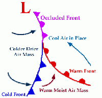
Occluded Fronts
Occluded fronts occur when a cold front overtakes a warm front. This often results from the merging of two cold fronts that overwhelm the warm front. The result is a weakening of the storm system that might otherwise occur.
- Active cold front overtakes a warm front
- Weather is complex
- Precipitation associated with warm air
There are two types of occluded fronts, known as cold occlusion and warm occlusion. In cold occlusion, the approaching cold air mass creating the cold front is colder than the retreating cold/cool air mass in front of the warm front. The opposite is true for warm occlusions, where the cold/cool air mass creating the cold front is warmer than the retreating cold air mass in front of the warm air mass. Also to note, cold occlusions are much more common than warm occlusions.
| Before Passing | While Passing | After is passes | |
|---|---|---|---|
| Winds | Southeast-south | Variable | West-northwest |
| Temperature (Cold Occlusion) | Cold-cool | Dropping | Colder |
| Temperature (Warm Occlusion) | Cold | Rising | Milder |
| Pressure | Usually falling | Low point | Usually rising |
| Clouds | In order Ci, Cs, As, Ns | Ns, sometimes Tcu and Cb | Light to moderate precipitation-clearing |
| Precipitation | Light, moderate or heavy | Continuous light, moderate or heavy | Light to moderate, then clearing |
| Visibility | Poor | Poor | Improving |
| Dewpoint | Steady | Slight drop | Slight drop, may rise if warm occluded |
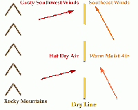
Dry Lines
A dry line is a line that separates a moist air mass from a dry air mass. It can also be referred to as a dew point front because the dew point temperature changes drastically across the dry line. The most common place to find a dry line is just east of the Rocky mountains separating the dry air that comes over the mountains from the moist air coming off of the Gulf of Mexico and the Atlantic ocean. Dry lines are extremely rare east of the Mississippi River.
Front Symbols
| Types | Stationary front | Cold front | Warm front | Occluded front | Dry Line |
|---|---|---|---|---|---|
| Symbol |
Precipitation and Clouds
Water in the Atmosphere
The atmosphere of our planet is laden with water. In temperate and tropical regions, water exists mainly in liquid form. At the poles and higher latitudes, much of Earth’s water exists as ice locked away in alpine or continental glaciers. The physical composition of Earth’s atmosphere consists primarily of water vapor.
Humidity refers to the amount of water vapor that is in the air. This water vapor exists in a gaseous state. The process in which water changes from a liquid into a gaseous state is evaporation. Each water molecule that becomes water vapor also takes with it a parcel of heat energy from the surface it evaporates from cooling the surface (evaporative cooling). Evaporative cooling explains why someone may feel a chill after swimming as water evaporates off the surface of their skin, taking with it heat from their body.
During the spring when the amount of daylight is increasing and the declination of the hemisphere is tilting towards the Sun, the intensity of solar radiation increases causing ice crystals in the upper troposphere to melt and fall as rain. As the water is exposed to increased solar radiation it evaporates and returns to the atmosphere in a gaseous state-as water vapor. The humidity of the atmosphere increases as spring changes to summer.
Water vapor is measured using an instrument known as a hygrometer. Measurements of humidity are often expressed as a percentage, which is termed relative humidity. The complete saturation of the air (100% relative humidity) occurs when the amount of water vapor in the air equals the amount of water vapor that the air can hold.
Precipitation
Precipitation is any form of water that falls to the surface of Earth. The most common forms are:
- rain
- snow
- sleet
- hail
Liquid Precipitation
Liquid precipitation is classified in three ways.
- Mist consists of droplets less than .05mm in diameter.
- Drizzle is anything larger than .05mm but less than .5mm
- Rain is anything larger than 0.5mm across. Most raindrops are not larger than 5mm across because of air drag effects that would tear larger droplets into smaller droplets as they descended.
Frozen Precipitation
Frozen precipitation also comes in various forms.
- Snowflakes fall as ice crystals and have diameters of between 1mm and 2cm. They form through deposition of water vapor onto particles such as dust, and the water vapor is directly converted into ice.
- Graupel is around 5mm and falls as soft and mushy ice. It essentially consists of snowflakes that have accumulated large masses of rime, to the extent that the original snowflake's structure is completely obscured.
- Sleet is similar to graupel but smaller, forming when raindrops freeze as they fall.
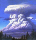
- Hail is larger than 5mm and is formed from rounded clumps of hard, layered ice. It is usually associated with thunderstorms. Each individual hailstone is repeatedly cycled through the interior of a thunderstorm by strong updrafts, allowing layers of ice to accumulate before it finally becomes too massive and falls to the ground.
- Rime is a deposit of ice that freezes onto a surface that has a temperature below 0 °C. Rime forms from water droplets that are supercooled: below the freezing point, but unable to freeze into ice until encountering something (similar to the concept of supersaturation). Rime droplets are very small, and can often be observed on snowflakes.
Virga
Virga is precipitation that falls from clouds but evaporates while falling and never reaches the surface of the Earth. At high altitudes, precipitation falls mainly as ice crystals before they melt and evaporate before reaching the ground because of compressional heating that occurs as a result of increasing air pressure closer to the ground (remember- air that is compressed becomes warmer).
Streams of falling precipitation that never reach the ground make the clouds appear to have commas attached to them as aloft winds push the bottom ends of the virga into angles. Virgas can be hazardous to pilots because the pockets of extremely cold air descending from the upper atmosphere can create microbursts.
Clouds
Clouds are small droplets of water and ice crystals that clump together within the atmosphere. They may produce precipitation in the form of liquid water and/or ice crystals that fall onto the Earth’s surface.
Formation of Clouds
Cloud formation is closely related to the cooling of humid air as it rises. When water vapor expands, it cools in temperature. Likewise, when air is compressed, it heats up. This change in temperature, caused by the expansion or contraction of gases and not by the increase or irradiation of heat, is known as adiabatic temperature change. As humid air rises, it is under less pressure and expands, causing its temperature to decrease.
The air’s capacity to hold water vapor is temperature dependent. Warmer air holds more moisture, while cooler air holds less. When the air cools, it eventually reaches the dew point temperature. At the dew point temperature, air is saturated with water vapor. Excess water vapor condenses (changing from a gas into a liquid) on large aerosol particles to form a cloud.
The dew point and relative humidity can be measured using a psychrometer, which consists of two thermometers mounted side by side, the dry bulb and the wet bulb. The dry bulb measures air temperature. The wet bulb has a damp wick wrapped around it, which allows it to measure any decrease in temperature. The decrease in temperature measures the evaporation in the damp wick.
To use a psychrometer, expose it to a flow of air by slinging it around on a handle. The humidity of the air is directly proportional to the amount of moisture evaporating off the wet bulb. If the two thermometers have identical readings, then no evaporation has taken place and the air is saturated with water vapor. The bigger difference between the two thermometers, the drier the air and the lower the level of humidity.
Cloud Identification
It is important to be able to identify clouds and the weather associated with each cloud.
Clouds are classified by height of the ground. The following list of classification is made from Richard Hamblyn's The cloud book: how to understand the skies:
- Upper Clouds are located around or above 9000 meters. These clouds often have prefix "cirr-".
- Examples: Cirrus, Cirrocumulus, Cirrostratus
- Intermediate/Medium Clouds are located between 3000 and 7000 meters. These clouds often have prefix "alto-".
- Examples: Altocumulus, Altostratus, Nimbostratus
- Lower Clouds are located below 2000 meters.
- Examples: Stratocumulus, Stratus, Cumulus.
- High Fogs are located under 1000 meters.
- Multilevel clouds can span a wide range of heights.
- Example: Cumulonimbus.
Types of Clouds
Optical Phenomena
There are many types of weather phenomena but here are the major ones.
| Picture | Name | Description |
|---|---|---|
| Mirage | An optical phenomenon that occurs when light is refracted to produce an image of an object or the sky where it is not. | |
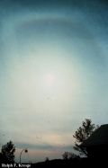
| Halo | Like rainbows, haloes are formed around the Sun due to moisture being refracted from the Sun’s rays in the upper atmosphere. | |
| Sundog | An atmospheric phenomenon that creates bright spots of light in the sky, often on a luminous ring or halo on either side of the sun. | |
| Virga | An observable streak or shaft of precipitation that falls from a cloud but evaporates or sublimes before reaching the ground. | |
| Rainbow | An atmospheric phenomenon that is caused by reflection of light in water droplets in the Earth's atmosphere, resulting in a spectrum of light appearing in the sky. | |
| Crepuscular Ray | Rays of sunlight that stream through gaps in clouds (particularly stratocumulus) or between other objects whose columns of sunlit air are separated by darker cloud-shadowed regions. | |
| Aurora Borealis | A natural light display in the sky particularly in the high latitude regions, caused by the collision of energetic charged particles with atoms in the high-altitude atmosphere. | |
| Green Flash | An optical phenomenon that occurs shortly after sunset or before sunrise, when a green spot is visible, usually for no more than a second or two, above the sun, or it may resemble a green ray shooting up from the sunset point. | |
| Belt of Venus | Occurs during dusty evenings when a band of pinkish or brownish sky will appear between the sky and the horizon. | |
| St Elmo’s Fire | Luminous plasma that appears like fire on objects, such as the masts of ships or lightning rods. |
Weather Technology
Instruments
| Instrument | Uses |
|---|---|
| Actinometer | measures solar radiation |
| Barometer | measures air pressure |
| Barograph | makes a continuous recording of atmospheric pressure |
| Ceilometer | measures the height of a cloud base |
| Evaporimeter | measures evaporation of water |
| Hygrometer | measures moisture content of gases/gas |
| Psychrometer | measures relative humidity |
| Radiosonde | measures various atmospheric parameters and transmits them to a fixed receiver. Radiosondes are usually placed in weather balloons. |
| Rawinsonde | a radiosonde that is designed to only measure wind speed and direction. |
| Rain gauge | measures rainfall |
| Thermometer | measures temperature |
| Wind vane | shows wind direction |
Forecasting
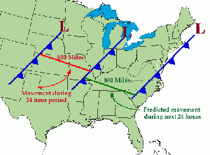
There are many ways to forecast, but the simplest way is to take today's weather and say that tomorrow is going to be the same. This can be called the Persistence method. This method is useful in some places (e.g., Florida during the summer) but can also be very unreliable in other places (e.g., Chicago during the spring).
The next method can be called the trends method it relies on mathematics to forecast. This method involves being able to get a accurate measurement of the speed at which the weather system is moving and putting the numbers into (S=d/t) and determining the time at which the system will be at a position. Here is an example of the trend model:
The Climatology Method is another easy way of forecasting. This method involves averaging weather statistics accumulated over many years to make a forecast.
The Analog Method is a more complicated method of producing a forecast. It involves examining today's forecast scenario and remembering a day in the past when the weather scenario looked very similar. The Analog Method uses that previous information to predict that today's weather will be similar.
Radar
Radar is a very important part of today's meteorology because it allows early warning of approaching storms and rain.
Radar Basics
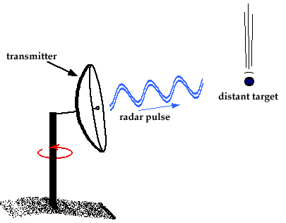
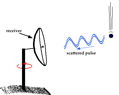
Radar is a simple concept: a beam is sent out and reflects back to an antenna that collects the beam and sends it via wire to a receiver. The return signals are arranged to produce a radar image.
When the beam of energy (electromagnetic) hits the target, it is reflected in all directions, some going up, some going down, some going back to the original point. The most important part is the returning energy. The returning energy is much weaker when it is returning than when it left. The size of the reflecting particle determines the strength of the return signal. This means that the larger the particle, the stronger the signal, and the smaller the particle, the weaker the signal. Also the more particles there are, the stronger the return signal because the returning beams combine to form a stronger signal
The amount/size of the reflectivity is proportional to the number and size of the drops encountered by the electromagnetic pulse. Because of this, high reflectivity normally means heavy precipitation while low reflectivity means lighter precipitation.
Since radar uses electromagnetic pulses or electromagnetic waves, wavelength affects the signal and pulses. The two wavelengths are short and long wavelengths. Short wavelengths are good at measuring small particles like dust and cloud droplets. However, the short wavelengths are also easily absorbed by the materials it reflects off (this is called attenuation). This feature makes it hard to measure distant targets.
Long wavelengths have the advantage that absorption by the particles is reduced. This feature makes this wavelength very useful for looking at severe storms and other large scale/distant weather. Long wave radar is used in most Doppler radars like the National Weather Service's WSR-88D (NEXRAD) Doppler radars.
Reading Weather Maps/Satellite Imagery
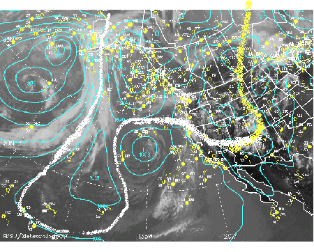
A good place to start is a basic weather map, the kind that is frequently seen at competitions:
- Start by identifying the different pressure zones on the map. Above it is already done but if it wasn't marked look for sections that have a circle with a very high or low pressure.
- Look for fronts. This can be done by looking at the station ball symbols. (those are the yellow circles with the tails the tails indicate wind direction) look and find a sudden change in wind direction/pressure that will normally indicate a front. I marked where I believe a front to be.
There are many lines on this map. Each one means something:
- The blue lines are isobars which mean that they are lines of constant pressure.
- The yellow circles with "tails" are called station ball symbols of station models; they are explained in the next section.
Another feature that is common on weather maps are isotherms. Isotherms are lines drawn across the map that connect points that have the same temperature.
Station Models
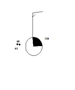
The above image is a station model. It can tell many different measurements, such wind speed, wind direction, temperature, dew point, current weather, cloud cover, and pressure. Some symbols have more information than others on them, but here is a basic overview:
- The 48 is the current temperature
- The 45 is the dew point
- The symbols between the two numbers represent the current weather. On this station model, it represents a light rain.
 The flag is what tells information about the wind. The direction the stick faces shows the wind direction, and how many lines on the end of it show the wind speed. A half line signifies five knots, a full line ten knots, and a bold line 50 knots.
 This indicates how much cloud cover there is. There are nine choices:
| Picture | Meaning | Picture | Meaning | Picture | Meaning | Picture | Meaning | Picture | Meaning | Picture | Meaning |
|---|---|---|---|---|---|---|---|---|---|---|---|
| Clear | 1/8 | 1/4 | 3/8 | 1/2 | Missing | ||||||
| 5/8 | 3/4 | 7/8 | overcast | Obscured |
Symbols

Rawinsondes/Radiosondes
Rawinsondes and Radiosondes are interconnected they both are part of the weather equipment launched in weather balloons.
A radiosonde or rawinsonde will normally record and "observe"
- Pressure
- Altitude
- Location (coordinates)
- Temperature
- Wind speed and direction
METAR
This is a way that meteorologists convey what is happening at a point on Earth. It is a very abbreviated language. Here is an example of METAR:
KCLL 312253Z 14007G15KT 10SM CLR 31/15 A2990 RMK AO2 SLP120 T03110150
| Abbreviation | Explanation | What it says |
|---|---|---|
| KCLL | Where the METAR station is located. | |
| 312253Z | The date and time in Zulu * | This says that it is the 31st of the month and is 22:53 Zulu. |
| 14007G15KT | Wind direction and speed | This says that the wind is from 140 degrees at 7kt with gusts to 15 kts. |
| 10SM | Visibility | This says there are 10 statute miles of visibility. |
| CLR | Clear skies | |
| 31/15 | Temperature and Dew point in Celsius. | |
| A2990 | Inches of mercury | The air pressure is 29.90 inHg. To get millibars, multiply by 33.863. |
| RMK | Remarks | This is where the station will post clarification data. |
| A02 | Type of automated station | AO1: automated station without a precipitation discriminator; AO2: automated station with precipitation discriminator. |
| SLP120 | Sea level pressure | |
| T03110150 | Actual temperature, dew point | This says that the temperature is actually 31.1 and the dew point is 15. |
Zulu is a time measurement based on a 24-hour clock
here is a more in-depth METAR guide: http://www.met.tamu.edu/class/metar/quick-metar.html
Stuve Diagrams
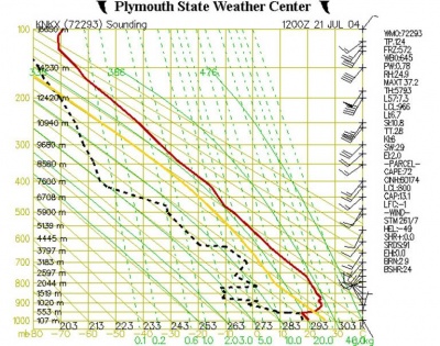
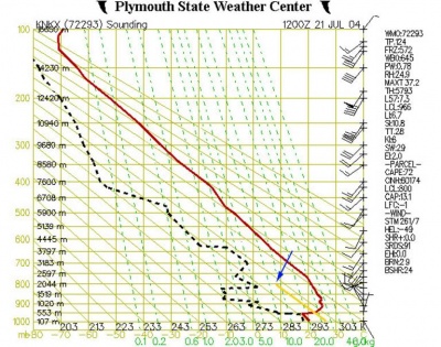
A Stuve diagram is the compilation of data gathered in Weather Balloon flights.
As seen, the image above is extremely cluttered and hard to understand at first.
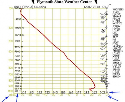
This image shows the Stuve diagram at its most basic level. The left Y-axis shows air pressure and elevation (in meters).
The X-axis shows temperature in Kelvin and well as Celsius.
The yellow vertical lines represent isotherms or lines of constant temperature, and the yellow horizontal lines represent isobars, or lines of constant pressure.
The "barbs" along the right side show wind speed and direction. They are on the same scale as the Station Model symbols.
The red line shows the relationship between air temperature and altitude.
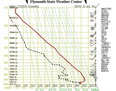
In this diagram, dashed green and dashed black lines have been added.
The dashed green line shows the saturation mixing ratio: the amount of water vapor needed in a parcel of air (the amount needed to make a cloud).
The black line shows how the dew point temperature changes with altitude.
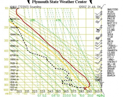
In this diagram, a yellow line and solid diagonal lines have been added.
The yellow line shows the temperature of a parcel of air as it moves through the atmosphere.
The solid diagonal lines are called dry adiabats and show the rate at which unsaturated of dry air will cool down as it rises through the atmosphere, at a rate of about 10˚C/km.
If an air parcel is initially unsaturated, it will cool off at the dry adiabatic lapse rate as it rises (note that the yellow line is parallel to the solid diagonal lines).
Assume parcel of air starts off at an altitude of 500m with a temperature of 22˚C. If it is lifted up, it will cool off at 10 °C for every km it rises. This is shown by the yellow line. At an altitude of 2000m, it will have cooled to a temperature of about 7˚C. At this point it has cooled down enough that it is now saturated.
Why does this happen?
Remember that the saturation mixing ratio at any temperature and pressure can be found using the dashed green lines on the graph. At 800 mb and 7˚C (where the yellow line ends), the dashed green line which would go through this point would have a value of 8 g/kg. This is the saturation mixing ratio for this point.
However, this was also the actual mixing ratio for this air parcel. Now, the air has cooled down enough that the actual mixing ratio is the same as the saturation mixing ratio. The altitude at which this happens is the lifting condensation level (LCL). This is the point at which moisture contained in a rising parcel of air can begin to condense. this is shown in the list of data at the right-hand side of the figure. Look under “PARCEL”, then find “LCL:800”. This indicates that the lifted air parcel would reach its lifting condensation level at 800 MB.
The last part of a Stuve diagram is the solid green lines which are referred to as saturated adiabats. These show the rate at which saturated air cools as it rises.
The lines are somewhat curved because the saturated adiabatic lapse rate fluctuates between 2˚C/km to nearly 10˚/km (the dry adiabatic lapse rate), depending on moisture content of the parcel of air.
Images above come from this site
Meteograms
A meteogram is a mix of station ball symbols and metar.
The graph along the top of the Meteogram shows temperature and Dew point. temperature is the top line(green) and dew point is the bottom line (blue)
The abbreviation EXTT (extreme temperature) shows the maximum and minimum temperatures which are plotted below the chart at specific reporting times. 12Z and 18Z are generally low temperatures and 0Z and 6Z are high temperatures.
The WX shows the current weather data at the time of data collection.
SNWDP shows snow-depth if there is any.
PREC tells precipitation in inches.
VIS tells visibility in miles.
WGST tells wind gusts.
WIND (winds and cloud cover) - This is same symbols wind and cloud cover symbols used in the station models.
Cloud chart will give cloud layer information. The vertical axis is the height of cloud base in feet. The layers are plotted as horizontal lines.
- Clear skies are plotted as a 'C'.
- Scattered cloud layers (1/8th to 3/8th coverage) are plotted as a single short dash.
- Broken cloud layers (4/8th to 7/8th coverage) are plotted as two short dashes. *Overcast layers are plotted as a single long dash.
The actual cloud ceiling is displayed below the chart in 100s of feet if the ceiling is below 10,000 feet.
Pressure chart - This chart plots sea level pressure (or altimeter setting if pressure not reported) in millibars.
Beaufort Scale
Reference
Calculation of Degree Days
From a meteorological standpoint, degree days are defined with respect to 65 F as a reference point. Degree days can be calculated with other reference values than 65, but the National Weather Service standard is 65 degrees. The National Weather Service calculates it as follows:
The daily high and low temperature, both measured to the nearest whole degree Fahrenheit, are averaged. If the average is not an integer, it is rounded up. Subtract this average from 65. If it is a positive quantity, it is the number of COOLING degree days for that day. If it is negative, its absolute value is the number of HEATING degree days.
As an example, yesterday in Omaha, Nebraska the high was 55 and the low 28. Averaging those two numbers:
[math]\displaystyle{ \text{Average} = \frac{\text{High} + \text{Low}}{2} = \frac{55 + 28}{2} = \frac{83}{2} = 41.5 }[/math]. This needs to be rounded up to 42 (it is always rounded up).
[math]\displaystyle{ \text{Degree Days} = \text{Average} - 65 = 42 - 65 = -23 }[/math]. It's negative so yesterday there were 23 HEATING degree days in Omaha.
Degree days are reported daily in climate summaries issued by the National Weather Service. Monthly and yearly sums of the daily degree days are also reported. Counts for heating and cooling degree days are kept separate.
Note: the "year" for heating degree days is typically that sum from the period July 1-June 30, while cooling runs from January 1-December 31.
Glossary
ExpandGlossary
|
Additional Topics
The following concepts were not included in the 2019 event rules for Meteorology as topics for competition, although they may be useful to understand or have been included in previous years.
ExpandAdditional Topics
|
Links and Resources
- The cloud book: how to understand the skies by Richard Hamblyn
- Great Meteorology site, source of some of this page's images
- GoNerdHerd's 2010 Everyday Weather Notes
- EpicFailOlympian's 2010 Everyday Weather Notes


