Dynamic Planet/Oceanography
| Dynamic Planet/Oceanography | |||||||
|---|---|---|---|---|---|---|---|
| Type | Earth Science | ||||||
| Category | Study | ||||||
| Event Information | |||||||
| Latest Appearance | 2021 | ||||||
| Forum Threads | |||||||
| |||||||
| Question Marathon Threads | |||||||
| |||||||
| Official Resources | |||||||
| Division B Website | www | ||||||
| Division C Website | www | ||||||
| Division B Results | |||||||
| |||||||
| Division C Results | |||||||
| |||||||
- This article is about the topic of Dynamic Planet for the 2020 and 2021 seasons. For information about the event in general, see Dynamic Planet Topics.
Oceanography is the topic of Dynamic Planet for the 2020 and 2021 seasons. In the past, it was in rotation for the 2007 and 2008 seasons, and as well as the 2015 and 2016 seasons.
Overview
During the 2020 season, this event will focus on physical and geological oceanography. Physical oceanography is primarily concerned with the ocean as a physical system in which principles like conservation of mass, energy, momentum and spin play a huge role in determining what you see. Geological oceanography looks at the rocks and sediments on the ocean bottom and margins and tries to infer how that got that way and what that tells us about the history of the earth.
The Competition
The competition consists of a test covering the geological and physical aspects of the ocean. Usually this test will be presented in stations, which competitors will rotate from after a certain period of time. To be successful, competitors should possess a mix of practical and theoretical skills. Practical skills should involve knowing how to read plots and graphs, particularly line plots, scatterplots, and contour plots. Theoretical skills should include an understanding of the Coriolis force, surface waves, and how the ocean interacts with the atmosphere. You should also study ocean geography.
Each team may bring a single binder of a size of two inches or less. In addition, each team may bring up to two of any type of calculator.
Plate Tectonics
Plate tectonics is a theory that describes the large-scale movement of the Earth's lithosphere. The lithosphere is divided into tectonic plates, and where they meet, they interact by either converging (known as a convergent plate boundary), diverging (known as a divergent plate boundary), or sliding next to each other in opposite directions (known as a transform plate boundary).
These interactions may be further defined by the composition of the two lithospheric plates at the boundary. Continental crust is composed primarily of granitic rocks while oceanic crust is comprised primarily of basaltic rocks. As a result, oceanic crust has a higher density than continental crust. Oceanic crust is generally 2.9 grams per cubic centimeter as opposed to continental crust, which is generally 2.7 grams per cubic centimeter. In addition, continental crust is thicker than oceanic crust.
Divergent Plate Boundaries
Usually associated with Mid-Ocean Ridges.
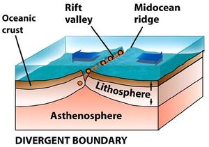
Ocean-Ocean Divergence
When a divergent boundary occurs beneath oceanic lithosphere, the rising convection current below lifts the lithosphere producing a mid-ocean ridge. Extensional forces stretch the lithosphere and produce a deep fissure. When the fissure opens, pressure is reduced on the super-heated mantle material below. It responds by melting and the new magma flows into the fissure. The magma then solidifies and the process repeats itself.
The Mid-Atlantic Ridge is a classic example of this type of plate boundary. The Ridge is a high area compared to the surrounding seafloor because of the lift from the convection current below. (A frequent misconception is that the Ridge is a build-up of volcanic materials, however, the magma that fills the fissure does not flood extensively over the ocean floor and stack up to form a topographic high. Instead, it fills the fissure and solidifies. When the next eruption occurs, the fissure most likely develops down the center of the cooling magma plug with half of the newly solidified material being attached to the end of each plate.
Continent-Continent Divergence
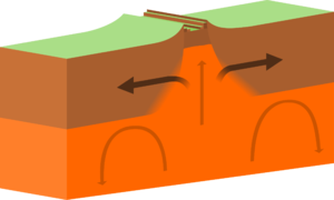
When a divergent boundary occurs beneath a thick continental plate, the pull-apart is not vigorous enough to create a clean, single break through the thick plate material. Here the thick continental plate is arched upwards from the convection current's lift, pulled thin by extensional forces,and fractured into a rift-shaped structure. As the two plates pull apart, normal faults develop on both sides of the rift and the central blocks slide downwards. Earthquakes occur as a result of this fracturing and movement. Early in the rift-forming process, streams and rivers will flow into the sinking rift valley to form a long linear lake. As the rift grows deeper it might drop below sea level allowing ocean waters to flow in. This will produce a narrow, shallow sea within the rift. This rift can then grow deeper and wider. If rifting continues a new ocean basin could be produced.
The East Africa Rift Valley is a classic example of this type of plate boundary. The East Africa Rift is in a very early stage of development. The plate has not been completely rifted and the rift valley is still above sea level but occupied by lakes at several locations. The Red Sea is an example of a more completely developed rift. There the plates have fully separated and the central rift valley has dropped below sea level.
Convergent Plate Boundaries
Usually creates a trench, and often can also produce volcanoes.
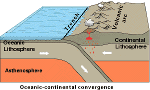
Ocean-Continent Convergence
Oceanic crust subducts under continental crust, which forms a trench (like the Mariana trench). Due to the heat of the mantle, the subducting ocean crust melts and rises through the crust to form and composite volcano. Earthquakes are prevalent at this plate boundary.
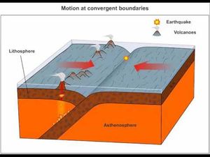
Ocean-Ocean Convergence
Formation of a destructive center. Both oceanic plates subduct. Trenches form, possible volcanoes or volcanic island arcs. Earthquakes and tsunamis are also common.
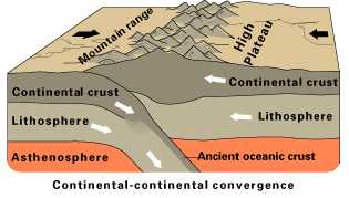
Continent-Continent Convergence
Causes both plates to heave up, and creates a mountain range. A great example would be the Himalayan mountain range as the Indian subcontinent pushes upon Asia and converge.
Transform Plate Boundaries
Transform boundaries are places where plates slide sideways past each other. At transform boundaries lithosphere is neither created nor destroyed. Many transform boundaries are found on the sea floor, where they connect segments of diverging mid-ocean ridges. California's San Andreas fault is a transform boundary. Earthquakes also happen here.
Continental Margins
Active Margins
Active continental margins, where plates are converging, coincide with plate boundaries, where the continental and oceanic crust are separated by a subduction zone. These margins are active tectonically and have less width and sediment input than passive margins. They are also marked by the addition of blocks from distant sources to the continental mass at the subduction zone.
Passive Margins
Passive margins are within plates and are separated from the oceanic ridge plate margin by an expanse of oceanic crust that was generated after rifting. Oceanic and continental crust meet in a region of low tectonic activity that does however experience a broad pattern of subsidence. Passive margins are generally wide and may receive a large influx of terrigenous sediments or intrabasin carbonate sedimentation from local sources.
Reef Formation
A volcanic island is formed by tectonic activity and the shores are warm where coral can grow. Charles Darwin developed the reef classification system.
Fringing Reef
The coral starts forming because it is attracted to the heat from the hydrothermal vents. Soon more animals move in creating a coral reef. This reef fringes of the island hence the name "Fringing Reef".
Barrier Reef
The reef continues to grow, but the volcanic island starts to erode away leaving a stub of island left. Yet it is warm enough for the coral to grow and the coral continues almost creating something along the lines of a barrier.
Atoll Reef
The island has disappeared completely only leaving traces of the once island. The coral still remains and where the island was is now a lagoon.
A picture depicting the reef formation processes: 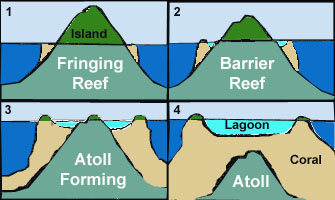
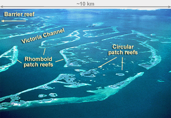
Patch Reef
The term "Patch Reef" is commonly used to describe reefs which do not fall under Darwin's reef classification scheme. They are usually clumps of corals that are close to each other, but not connected, usually being separated by sand or muck. There are 2 main types of patch reefs: circular and rhomboid. An image of patch reefs is below.
Oceanic Circulation
Thermohaline Circulation
The term thermohaline circulation refers to the part of the large-scale ocean circulation that is thought to be driven by global density gradients created by surface heat and freshwater fluxes. The adjective thermohaline derives from "thermo-", referring to temperature, and "-haline", referring to salt content. These factors together determine the density of sea water. The thermohaline circulation is sometimes called the ocean conveyor belt, the great ocean conveyor, or the global conveyor belt. On occasion, it is used to refer to the meridional overturning circulation (often abbreviated as MOC).
Surface Currents
Gyres
A gyre in oceanography is any large system of rotating ocean currents, particularly those involved with large wind movements. Gyres are caused by the Coriolis Effect; planetary vorticity along with horizontal and vertical friction, which determine the circulation patterns from the wind curl (torque). Five major gyres are: Indian Ocean Gyre (Majid Gyre), North Atlantic Gyre (Columbus Gyre), North Pacific Gyre (Turtle Gyre), South Atlantic Gyre (Navigator Gyre), and South Pacific Gyre (Heyerdahl Gyre).
Coastal Currents
Coastal currents are, predictably, currents that flow along/around the coastline. These currents are affected by wind, waves, and the land by which they flow. There are two main types of coastal current: longshore currents and rip currents.
Longshore Currents
Longshore currents are affected and generated by waves hitting the coastline. As waves approach the coastline, parts of the wave hit the coastline first due to irregularities in the land. These parts of the wave are slowed down, while the other parts of the wave are not. This causes incoming waves to conform to the coastline, although note that waves do not approach the shore perpendicularly, but rather at different angles. (This angle is called the "angle of wave approach.") When a wave breaks on a coastline, it releases a burst of energy that fuels the formation of a current that runs on and off of the coastline; the longshore current. The strength of a longshore current is affected by the velocity and the angle of a wave. The higher the wave velocity and the lower (more acute) the angle of wave approach is, the stronger the longshore current will be. The strength of a longshore current is also increased by the slope of the beach. If the slope of the beach is high, the longshore current will be stronger. As the longshore current moves on and off/along the beach, it can "take" sediment away from the beach/coastline itself, which can lead to significant erosion, especially to man-made structures.
Rip Currents
Rip currents are strong channels of water that flow away from the shore. They are sometimes mistakenly called "rip tides," and are generated by the movement of longshore currents along/on and off of irregularities in the coastline such as low spots, sandbars, and piers. Rip currents flow at a perpendicular (or nearly perpendicular) angle to the coastline, and generally break up not far off the shore. Rip currents are usually not more than 80 feet wide. If wave activity is low, several small rip currents can form. As wave activity increases, the number of rip currents decreases, but those that do form are much stronger.
Upwelling
This is the process where water and nutrients from the bottom of the ocean rises to the top. Upwelling is found along places of surface divergence. This process is very important to countries because the nutrients are transferred to the continent and the farming is better. Upwelling also causes better fishing, since there is more primary productivity near the surface, seeing as how there is more nutrients.
Waves
Wave
The repeating and periodic disturbance that travels through a medium (e.g. water) from one location to another location.
Wave characteristics
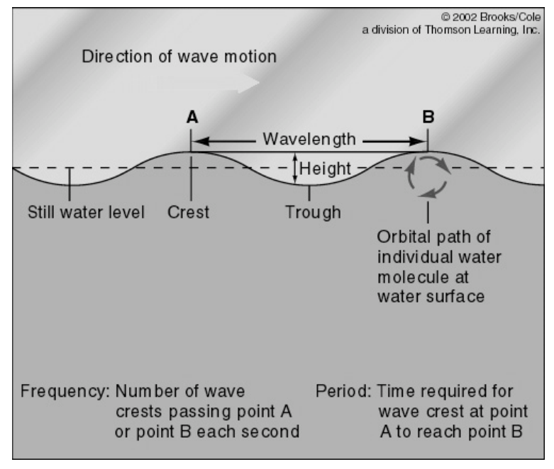
Wave crest - The highest part of a wave.
Wave trough - The lowest part of a wave.
Wave height - The vertical distance between the highest (crest) and lowest (trough) parts of a wave.
Wavelength - The distance from a certain point on one wave to the same point on the next wave (e.g. distance between two consecutive wave crests or between two consecutive wave troughs).
Wave amplitude - One half the distance from the crest to the trough. Wave amplitude is a more technical term for wave height and is used in engineering technology.
Wave frequency - The number of waves passing a fixed point in a specified period of time. Frequency has units of waves per second or cycles per second. Another unit for frequency is the Hertz (abbreviated Hz) where 1 Hz is equivalent to 1 cycle per second.
Wave period - The time it takes for two successive crests (one wavelength) to pass a specified point.
Wave speed - The distance the wave travels divided by the time it takes to travel that distance. Wave speed is determined by dividing the wavelength by the wave period. In symbols c = λ/T, where c is the wave speed, λ (lambda) is the wavelength, and T is the period.
Wave Steepness The ratio of height to wavelength. When (a traveling) wave steepness exceeds 1:7, breakers form. If a wave has a height of one foot and a length from crest to crest of 8 feet, then the ratio is 1:8 and this wave is not going to break. But if the height is 1 foot and the length decreases to 5 feet, then the ratio is 1:5 and this wave has now become so steep that the crest topples and the wave breaks. Breaking waves can be of the plunging type with violent impact of falling crest, or the more gentle kind called spillers, with turbulent white caps spilling down the front of the wave.
Types of Ocean Waves
Capillary waves Very small waves with wavelengths less than 1.7 cm or 0.68 inches. At such wave length, both gravity and surface tension forces play a role in defining wave characteristics such as wavenlength, steepness, and wave speed. They are the first waves to form when the wind blows over the surface of the water and are created by the friction of wind and the surface tension of the water. These tiny little waves increase the surface area of the sea surface and if the wind continues to blow, the size of the wave will increase in size and become a wind wave. Also known as Cat's Paw waves.
Chop Small waves causing the ocean surface to be rough.
Ripples The ruffling of the water’s surface due to pressure variations of the wind on the water. This creates stress on the water and results in tiny short wavelength waves called ripples. Ripples are often called capillary waves. The motion of a ripple is governed by surface tension.
Standing Wave Waves that move back and forth (oscillate) in a vertical position. They do not move forward but appear as crests and troughs in a fixed position. Standing waves are created when a wave strikes an obstruction head-on and then are reflected backwards in the direction they came from. Theoretically, standing wave breaks when its crest form a 90 degree angle, but capillary force can make it steeper and delay its breaking.
Swell The smooth undulation (rising and falling of waves) of the ocean surface that forms as waves move away from the storm center where they are created. As waves move out and away from the storm center, they sort themselves out into groups of similar speeds and wavelengths. This produces the smooth undulating ocean surface called a swell. Swells may travel thousands of kilometers from the storm center until they strike shore. Swells often evolve into surf, like those beautiful ones off the Hawaii beach.
Tides
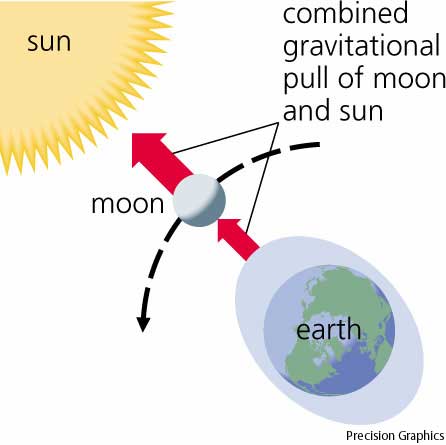
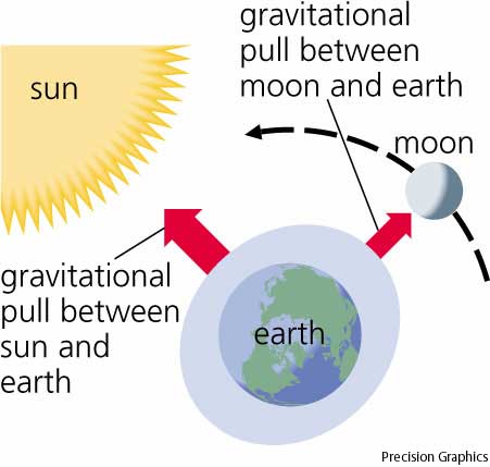
Tides are the daily ebb and flow of water caused by the gravitational pull of the sun and moon. Even though the sun is larger is volume, it is much farther away leaving the moon with a stronger pull on the water.
Spring Tides
Spring tides are the strongest tides because both the pulls of the sun and the moon are combined, but on the perpendicular sides the tides are fairly weak.
Neap Tides
El Niño Southern Oscillation
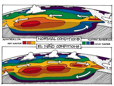
El Niño is a very important oceanographic phenomenon. El Niño and La Niña are officially defined as sustained sea surface temperature anomalies of magnitude greater than 0.5 °C across the central tropical Pacific Ocean. When the condition is met for a period of less than five months, it is classified as El Niño or La Niña conditions; if the anomaly persists for five months or longer, it is classified as an El Niño or La Niña episode. Historically, it has occurred at irregular intervals of 2-7 years and has usually lasted one or two years. Under normal conditions, there is the Walker circulation cell and rain and warm water is at the Southeast Asia side of the Pacific. There is upwelling near South America with cold water.
El Niño
El Niño occurs when the trade winds weaken and warm water from Southeast Asia go to West Pacific and there is no more upwelling and there is more rain. The Walker circulation cell has been broken and the trade winds reverse.
The first signs of an El Niño are:
1. Rise in air pressure over the Indian Ocean, Indonesia, and Australia 2. Fall in air pressure over Tahiti and the rest of the central and eastern Pacific Ocean 3. Trade winds in the south Pacific weaken or head east 4. Warm air rises near Peru, causing rain in the northern Peruvian deserts 5. Warm water spreads from the west Pacific and the Indian Ocean to the east Pacific. It takes the rain with it, causing extensive drought in the western Pacific and rainfall in the normally dry eastern Pacific.
El Niño's warm current of nutrient-poor tropical water, heated by its eastward passage in the Equatorial Current, replaces the cold, nutrient-rich surface water of the Humboldt Current, also known as the Peru Current, which support great populations of food fish. In most years the warming lasts only a few weeks or a month, after which the weather patterns return to normal and fishing improves. However, when El Niño conditions last for many months, more extensive ocean warming occurs and its economic impact to local fishing for an international market can be serious. During non-El Niño conditions, the Walker circulation is seen at the surface as easterly trade winds, which move water and air warmed by the sun towards the west. This also creates ocean upwelling off the coasts of Peru and Ecuador and brings nutrient-rich cold water to the surface, increasing fishing stocks. The western side of the equatorial Pacific is characterized by warm, wet low-pressure weather as the collected moisture is dumped in the form of typhoons and thunderstorms. The ocean is some 60 cm higher in the western Pacific as the result of this motion.
La Niña
In the Pacific, La Niña is characterized by unusually cold ocean temperatures in the eastern equatorial Pacific, compared to El Niño, which is characterized by unusually warm ocean temperatures in the same area. Atlantic tropical cyclone activity is generally enhanced during La Niña. The La Niña condition often follows the El Niño, especially when the latter is strong.
Table with La Niña and El Niño Effects
| El Niño | La Niña |
|---|---|
| Strong Equatorial Counter-Current | Strong Peruvian Current |
| Wetter than Average Winter over Florida | Higher Sea Level in the West Pacific |
| Pronounced Ridge in Polar Jet over Western North America | Stronger than Normal Subtropical Highs in Pacific |
| Drier than Average over Indonesia and Australia | Increased Snowfall in the North Western U.S. |
| Large-Scale Warming of Pacific | Oceanic Cooling of the Pacific |
Ocean Sediments
There are 4 main types of ocean sediments:
Lithogenous/Terrigenous Sediment
Lithogenous, or terrigenous sediment is ocean sediment that is derived from a land-based origin. Lithogenous sediments tend to be common near the continental margins, as that is closer to land, and most lithogenous sediments deposit relatively quickly. An example of a lithogenous sediment would be sand which has washed down a river into to ocean.
Biogenous Sediment
Biogenous sediment is ocean sediment that is derived from biological processes. Biogenous sediments are typically found in the ocean basins, as they deposit relatively slowly, and are often covered by lithogenous sediments near the continents. An example of a biogenous sediment would be a calcareous or silicious deposit from shells of tiny marine organisms depositing on the seafloor via marine snow.
Hydrogenous/Autochthonous Sediment
Hydrogenous sediments are sediments which are precipitated from the ocean water. These are uncommon in the natural world, as Lithogenous and Biogenous sediment make up the vast majority of all the ocean sediments. One example of a hydrogenous sediment would be an evaporite.
Cosmogenous Sediment
Cosmogenous sediments are ocean sediments which are derived from space, such as meteorites or asteroids falling into the ocean. They can be found at random throughout the ocean in very small amounts. Cosmogenous sediments are the rarest kind of ocean sediment.
Oceanic Tools
Acoustic Doppler Current Profiler: The Acoustic Doppler Current Profiler (ADCP) measures the speed and direction of ocean currents using the principle of “Doppler shift.” Measuring currents is a fundamental practice of physical oceanographers.
The "Bushmaster" and the "Chimneymaster": The Bushmaster and Chimneymaster are large collection nets that can be closed by a submarine using a system of hydraulic cylinders and cables. They collect intact communities of tube worms and all associated hydrothermal vent fauna, either on the seafloor (using the Bushmaster) or on a sulfide chimney (using the Chimneymaster).
Clod Cards: Clod cards are cards made of plaster of Paris or alabaster used to understand patterns of water motion over benthic organisms, which can help us understand the physiology and ecology of these organisms. By measuring how quickly clod cards dissolve, scientists can characterize near-bottom flow patterns.
Drifters: Using devices known as drifters, scientists can study the complexities of global ocean currents, and, in turn, the many systems that they influence. With advances in technology, drifters now provide researchers with information about ocean circulation patterns in real time.
Satellites: Satellites that detect and observe different characteristics and features of the Earth's atmosphere, lands, and ocean are often referred to as environmental satellites. Most environmental satellites have one of two types of orbits: geosynchronous or sun-synchronous.
Semipermeable Membrane Devices: Semipermeable membrane devices (SPMDs) are a passive sampling device used to monitor trace levels of organic contaminants. When placed in an aquatic environment, SPMDs accumulate hydrophobic (water-“hating,” fat-“loving”) organic compounds, such as polychlorinated biphenyls (PCBs), polyaromatic hydrocarbons (PAHs), and organochlorine pesticides from the surrounding waters.
Sonar: Sound Navigation and Ranging—SONAR—is used to find and identify objects in water. It is also used to determine water depth (bathymetry). Sonar is applied to water-based activities because sound waves attenuate (taper off) less in water as they travel than do radar and light waves.
Submersible Collectors: Many components make up a successful research submersible. The suction sampler and detrital sampler were designed to attach to different types of submersibles and collect many of the unique and fragile organisms found only in the deep ocean.
Trawls: Trawls, which are nets towed behind a boat to collect organisms, have been used by fishermen for centuries. Trawls are used to collect quantitative data of marine organisms, such as biomass, length and weight, and age class distributions. This data helps scientists in managing marine animal populations and preventing their overexploitation.
How to Use Maps
Topographic
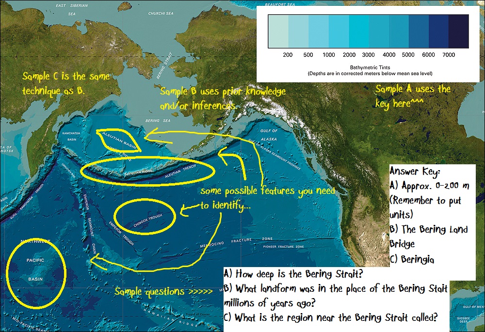
Look at the key then look at your map. Usually you can see the ridges very clearly at first glance. Look for any possible trench, canyon, seamount, etc. and then see the continents around it if you have to identify a specific trench, etc.
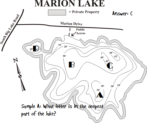
This can also be applied to maps like this. Every point on a contour line represents the exact same elevation, so eventually the line will close. Contour lines can never cross one another. Each line represents a separate elevation, and you can't have two different elevations at the same point. Moving from one contour line to another always indicates a change in elevation. To determine if it is a positive (uphill) or negative (downhill) change you must look at the index contours on either side. The closer contour lines are to one another, the steeper the slope is in the real world. If the contour lines are evenly spaced it is a constant slope, if they are not evenly spaced the slope changes.
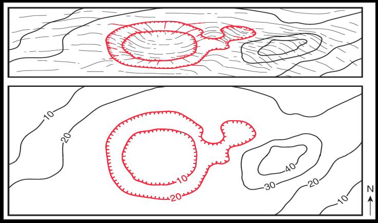 A series of closed contours (the contours make a circle) represents a hill. If the closed contours are hatchured it indicates a closed depression. Contour lines crossing a stream valley will form a "V" shape pointing in the uphill (and upstream) direction.
Bibliography: How to Use Topographic Maps
2016 Topics
As opposed to the 2020 rules, Dynamic Planet/Oceanography was slightly different in theme in 2016 (the last time it was in cycle). While the 2020 theme of dynamic planet is more focused on more physical oceanography, such as Ekman, geostrophic balancing, and wave physics. The 2016 theme was more focused on ocean chemistry, such as the distribution of chemicals in the oceans, ocean overturning, and seawater composition.
Meteorological Concepts
Fronts
A front is a kind of "wall" separating 2 masses of air with different densities. There are 4 main types of fronts; cold fronts, warm fronts, occluded fronts, and stationary fronts. Warm fronts typically yield frog and stratiform precipitation before the front moves through, and after the front passes the skies are usually clear. Cold fronts will usually yield thunderstorms and more severe weather. They are commonly associated with areas of low pressure, and are known to move up to twice as fast as warm fronts. An occluded front is where a cold front has overtaken a warm front. A stationary front, or stalled front, is where there are 2 masses of air in which they cannot mix to form an occluded front, and seem to remain in the same place for a long period of time.
Precipitation
Precipitation is rain or hail or any other form of water that would precipitate down into the ocean. Similarly to on land, snow and icy bodies of precipitation can be expected at higher latitudes, while usually only rain towards the equator.
Atmospheric Circulation
Prevailing Winds
Large regions of the earth that have winds that typically blow the same direction are called prevailing winds. In general, the prevailing winds at lower latitudes tend to be easterly (moving from the east to the west). In the middle latitudes, prevailing winds are typically westerly (moving from the west to the east). At higher latitudes, there typically aren't very many prevailing winds. A map of the world's prevailing winds and atmospheric circulation cells are shown below.
Example Questions
Question 1
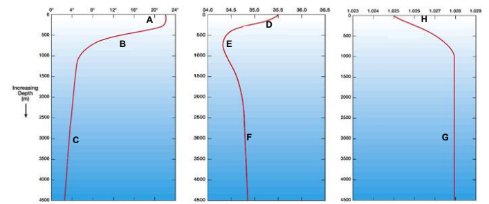
Which letter best describes the halocline?
Which letter best describes the pycnocline?
Explain what is occuring at letter E, and explain why that phenomona is happening.
Question 2
Explain how tidal resonance can occur, and give the wavelength for the highest tidal resonance.
Where in the world do we find the most tidal resonance on any given day?
Question 3
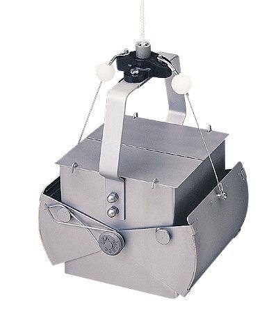
What is this ocean observing tool?
Why can't this ocean observing tool not operated efficiently or at all on a rocky bottom?
Reference
Tips
- An important aspect of this event (and Dynamic Planet topics in general) is understanding how to read a map. Reading maps is discussed in great detail in Road Scholar and Meteorology.
- For more information, see the Oceanography notes page.


