Dynamic Planet/Earth's Fresh Waters
- This article is about the topic of Dynamic Planet for the 2022 season. For information about the event in general, see Dynamic Planet Topics.
| Dynamic Planet/Earth's Fresh Waters | |||||||
|---|---|---|---|---|---|---|---|
| Type | Earth Science | ||||||
| Category | Study | ||||||
| Description | Students will use process skills to complete tasks related to Earth’s fresh waters. | ||||||
| Event Information | |||||||
| Latest Appearance | 2023 | ||||||
| Forum Threads | |||||||
| |||||||
| Question Marathon Threads | |||||||
| |||||||
| Division B Results | |||||||
| |||||||
| Division C Results | |||||||
| |||||||
Earth's Fresh Waters are the focus of Dynamic Planet for the 2022 season. The topic focuses on fresh water across Earth, such as lakes, reservoirs, and rivers.
Overview
The Competition
The competition will consist of you and your partner taking a test, possibly in the form of stations.
Teams may and should bring:
- One three-ring binder (any size) of notes
- Two calculators of any type
The Basics
Freshwater is water that has less than 0.2% of dissolved salts. Comparatively, freshwater is relatively scarce, comprising less than 3% of the Earth’s water supply. In addition, the majority of that, about 2%, is frozen away in glaciers and icecaps. Fresh water can also be found in lakes, rivers, streams, atmospheric vapor, and groundwater. Only about 0.5% of the Earth’s water is available for human and animal use, as atmospheric vapor, salt water, and icecaps are unavailable for use. The availability of freshwater is also limited by population, competition, and pollution. Further Information on Freshwater
- Weathering is the breaking down of material
- Erosion is the transportation of material
- Deposition is the placing of material
Hydrologic Cycle
For more information on the Hydrologic Cycle, please see the Hydrologic Cycle main page.
Streams
"Stream" is a general name for all moving water.
Stream Profile
In the case for large rivers, a delta or mouth of the river at sea level is a "Base Level", in fact, sea level itself is considered the "Ultimate Base Level". How can a waterfall be a base level? These pictures should shed some light on it.
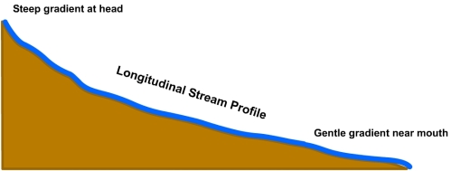
This picture shows a longitudinal profile, or a general profile of a river as compared to distance and elevation. As you can see in this picture, The origin is at the highest elevation, while the mouth is at the ultimate base level. By looking at this graphic, we can make some general assumptions:
1. The closer to the origin you are, the faster the water will flow
2. The closer to the mouth you are, the slower the water will flow
3. Sediment will be scoured closer to the higher elevation
4. Sediment will be deposited at the lower elevations
5. There is a higher stream gradient the closer to the origin you go
6. There is a lower stream gradient the closer to the mouth you go
So how does this work into waterfalls? Let me show you with another concept: Downcutting!
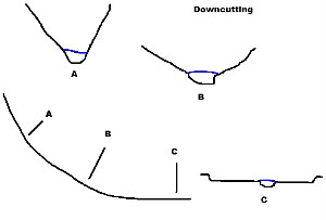
Downcutting is the deepening of a river channel relative to its surroundings. That is, how far does it dig into the ground. As natural examples tell us, The amount of downcutting on a river is dependent on where on the river it forms. Look at this example:
This picture shows what downcutting looks like on a normal river. At point “A”, the river is very fast moving and at a higher elevation to that of sea level, so it downcuts at a steady rate. At point “B”, the river is slowing down some, and is getting closer to sea level, so downcutting is considerably slower here than at Point “A”, and at Point “C”, downcutting is almost non-existent. However, science has shown us that downcutting does not continue down to sea level at the same speed in all cases. This is where we dive into the base level features.
Let’s review what we have determined so far:
Base level is the closest to sea level a river can go. Downcutting helps a river in its descent to ultimate base level.
Now, if downcutting doesn’t always continue to sea level, what blocks its path? Well, in order to understand this, we have to add a little onto our definition of a base level. Base level is the closest to sea level a river can flow at any one location. In other words, in real time, the base level at Point “A” on our graphic could be different to the Base Level of point “B”. It all depends on the rock layers. This is where we get into the final focus point.
At any one time, rock layers can dictate base levels.
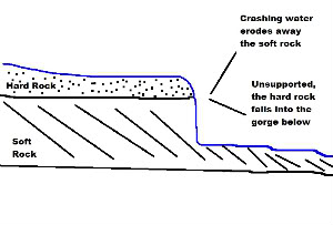
Geologically speaking, nothing impedes downcutting. However, at our timescale, we can witness downcutting happening before our very eyes. That is essentially what a waterfall is, an agent of downcutting. Look at this graphic of a waterfall:
By looking at the graphic, we can determine a definition. A waterfall is a morphological feature defined by water flowing over a hard rock layer. In the case of most waterfalls, the water that flows over the falls erodes the softer layer at the base. Once it erodes enough, the unsupported hard layer above collapses. This is what makes a waterfall appear to “retreat”. So how does this fit into river morphology? It acts like a new point of origin. Look at this final graphic:
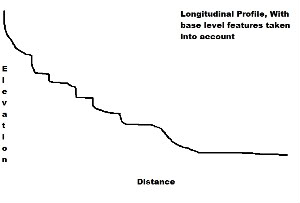
In actuality, this is what a longitudinal profile looks like, if you were to make it precise. Though mine is a sloppy mess, hopefully you can see what I’m trying to get across. It has these stair steps, base levels, that act as a mini origin, restarting the morphological process. These don’t have to be waterfalls. Lakes, other rivers, and even man-made dams have this kind of effect.
Stream Drainage
Streams follow a general pattern based on topography. Drainage Channels form where runoff cuts into the ground.
Channel Types
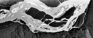
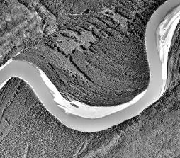
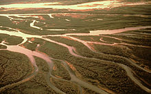
Straight, Meandering, Braided
Erosion and Depositon: Alluvial Landforms
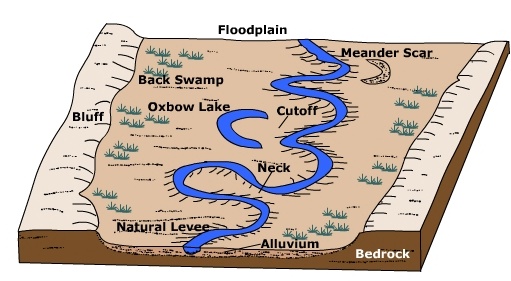
Once a stream reaches a base level it forms a large fertile valley due to its meandering:
Flood Plain
A flood plain is the flat area that tends to be covered in water when the river rises. As a flood increases the rivers size it slows the river down causing it to drop sediment which in turn allows for very fertile soil.
Natural Levee
A natural levee is formed when sediment(alluvium) is deposited along the edge of the stream forming a ridge
Meanders
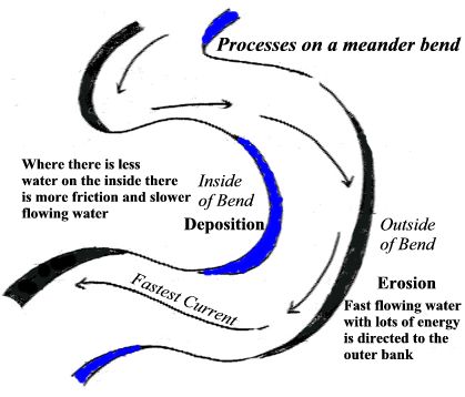
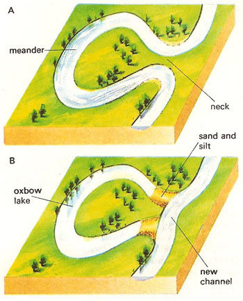
A meander is a bend in a stream. Meanders are prevalent in older streams. Meanders have erosion on the outer bank and deposition on the inner bank.
A point bar forms where the water going through a meanders drops alluvium on the inner bank
The neck is the point of land between the two edges of a meander.
The cutoff occurs when the stream erodes through the neck causing the river to be back to a straight course.
The result is an Ox-bow lake which is a separate body of water from the stream
Deltas
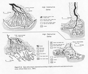
Deltas are formed when rivers meet large bodies of water like oceans. They are classified as follows:
- Constructional
- river-dominated
- elongate (digitate, bird foot delta)
- lobate
- Destructional
- tide-dominated
- wave-dominated
- cuspate (tooth shaped delta)
Other names for types of deltas: Arcuate delta, Estuarine delta
Stream Order
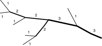
Arthur Newell Strahler developed a system known as stream order (or Strahler number) that helps determine how many tributaries a particular stream has and how large that stream is. Basically, start with the smallest stream, which has no tributaries; this is a first-order stream. Two first order streams join to make a second order stream, and so on. If a second-order stream joins a first-order stream, the resulting stream is still second-order.
This image explains it in a picture rather than in words:
Lakes
A lake is a body of water completely surrounded by land. More than 90% of Earth’s surface waters are contained in lakes. Less than 1% of Earth’s surface waters are found in rivers and streams at any moment in time. The origin of most lakes is not related to stream activity.
Conditions necessary for the formation and continued existence of a lake: 1. A natural basin with a restricted outlet; 2. Sufficient input of water to keep the basin at least partially filled.
Most of the world’s lakes contain fresh water. Less than 40% of lake waters are salty. Any lake that has no natural drainage outlet, either as a surface stream or as a sustained subsurface flow, will become saline. The water balance of most lakes is maintained by surface inflow, sometimes combined with springs and seeps from below the lake surface.
Lakes are stratified into several layers based on temperature. Many lakes have an upper warm layer called the epilimnion and a lower cold layer called the hypolimnion, which are separated by a transition zone called the thermocline.
Lakes can be classified in various ways, such as by their method of formation, nutrient levels, or levels of dissolved oxygen (DO).
Lakes are most common in regions that were glaciated within the relatively recent geologic past because glacial erosion and deposition have deranged the normal drainage patterns and have created innumerable basins. The series of large lakes in eastern and central Africa is due to major crustal movements and volcanic activity. Thousands of small lakes in Florida were formed by sinkhole collapse where rainwater dissolved calcium from massive limestone bedrock.
Most lakes are very temporary features in the natural landscape, geologically speaking. Few lakes have been in existence for more than a few thousand years: 1. Inflowing streams bring sediments to fill them up; 2. Outflowing streams cut channels that progressively deepen and drain lakes; 3. As lakes become more shallow, an increase in plant growth accelerates the process of infilling.
Dry lake beds located in desert regions are called playas. When temporarily filled by intermittent streams these bodies of water are called playa lakes. Permanent desert lakes are nearly always products of either subsurface structural conditions that provide water from a permanent spring or of exotic streams that have their source in nearby mountain.
Lakes may affect climate and weather: 1. It is generally more humid around lake areas; 2. Because water warms and cools more slowly than land, temperatures near lakes are generally milder than temperatures at the same latitude but more distant from lakes.
There is a lot to consider about lake organisms and chemicals. Chemicals such as nitrates and phosphates promote the growth of algae and fish. A lake with a lot of these chemicals is called "eutrophic". Eutrophic lakes generally have more algae, more fish, and less clear water. A lake with not a lot of chemicals are called "oligotrphic". These lakes have less organisms but generally clearer water. Eutrophic lakes are more likely to have a stream that feeds into it as well as be in bedrock than oligotrphic lakes. Oligotrophic lakes are generally found upstream and eutrophic lakes are found downstream. Lakes that are in the middle are called "mesotrophic" lakes.
Chemicals in lakes can come from pollution (fertilizers, a leaky septic tank) or natural sources. These chemicals can be naturally concentrated by the organisms in the lake.
Reservoirs
List of reservoirs by area
- 1. Lake Volta (8,482 sq km or 3,275 sq mi; Ghana)
- 2. Smallwood Reservoir (6,527 sq km or 2,520 sq mi; Canada)
- 3. Kuybyshev Reservoir (6,450 sq km or 2,490 sq mi; Russia)
- 4. Lake Kariba (5,580 sq km or 2,150 sq mi; Zimbabwe, Zambia)
- 5. Bukhtarma Reservoir (5,490 sq km or 2,120 sq mi; Kazakhstan)
- 6. Bratsk Reservoir (5,426 sq km or 2,095 sq mi; Russia)
- 7. Lake Nasser (5,248 sq km or 2,026 sq mi; Egypt, Sudan)
- 8. Rybinsk Reservoir (4,580 sq km or 1,770 sq mi; Russia)
- 9. Caniapiscau Reservoir (4,318 sq km or 1,667 sq mi; Canada)
- 10. Lake Guri (4,250 sq km or 1,640 sq mi; Venezuela)
List of reservoirs by volume
- 1. Lake Kariba (180 cu km or 43 cu mi; Zimbabwe, Zambia)
- 2. Bratsk Reservoir (169 cu km or 41 cu mi; Russia)
- 3. Lake Nasser (157 cu km or 38 cu mi; Egypt, Sudan)
- 4. Lake Volta (148 cu km or 36 cu mi; Ghana)
- 5. Manicouagan Reservoir (142 cu km or 34 cu mi; Canada)
- 6. Lake Guri (135 cu km or 32 cu mi; Venezuela)
- 7. Williston Lake (74 cu km or 18 cu mi; Canada)
- 8. Krasnoyarsk Reservoir (73 cu km or 18 cu mi; Russia)
- 9. Zeya Reservoir (68 cu km or 16 cu mi; Russia)
Groundwater
Check the Awesome Aquifers page for more information.
Groundwater is water that is in the ground. It exists in the pore spaces and fractures in rock and sediment. It originally was rainwater or snow. Water will move down into the earth until it reaches a layer of soil where it can not penetrate. This layer is called the impenetrable or impermeable layer. The uppermost reaches of this water is called the water table.
Facts:
- Groundwater makes up about 1% of the water on Earth. That's about 35 times the amount of water in lakes and streams.
- It occurs everywhere beneath the Earth's surface, but is usually restricted to depths less that about 750 meters.
- The surface below which all rocks are saturated with groundwater is the water table.
Further information on Groundwater
Hydraulic Head
The depth of groundwater in two different places, when measured, can give hydraulic gradient, basically a calculation of slope.
- hydraulic gradient (I) = (h1 - h2) / d
where h1 and h2 are two different heights, and d is the distance between them.
This allows us to calculate the velocity of groundwater flow, if we know porosity (a unitless percentage that describes what percentage of a rock, gravel, or sand is empty) and permeability (the variable K).
- groundwater velocity (V) = hydraulic conductivity (K) x hydraulic gradient (I) / porosity
Darcy also found out how to determine groundwater discharge using this information and the area the water flows through.
- discharge (Q) = hydraulic conductivity (K) x hydraulic gradient (I) x area (A)
Some resources on groundwater discharge and aquifers
More resources on groundwater discharge and aquifers
Wetlands
Wetlands are areas where the ground is often if not always saturated with water. There are swamps, peatlands, fens and marshes (which yes, are all different). They tend to be acidic and have unique ecological communities.
Karst Topography
Karst topography is a distinctive landform assemblage developed as a consequence of the dissolving action of water on carbonate bedrock (usually limestone, dolomite, or marble). Types of Karst features include sinkholes, solution valleys, springs, disappearing streams, and caves developed as a consequence of subsurface solution.
Sinkholes are commonly funnel-shaped and broadly open upward. Sinkholes may be a few feet to more than 100 feet in depth, though usually ranging from 10 to 30 feet. Sinkhole diameter sizes range from a few square yards to several acres in area. Another name for sinkholes are cenotes. Note that not all sinkholes are linked to Karst landscapes.
Solution valleys (or Karst valleys) are the remains of former surface stream valleys whose streams have been diverted underground as karst developed. They may develop a series of sinkholes in the valley floor.
Karst springs occur where the groundwater flow discharges from a conduit or cave. Karst springs or "cave springs" can have large openings and discharge very large volumes of water. Sinkholes and sinking streams that drain to a large karst spring can be many miles away from the spring. Streams flowing along the surface may enter a sinkhole as a "disappearing stream" and flow underground for some distance to reappear at the surface.
Caves (or caverns) are large, open underground areas occurring in massive limestone depositions at or near the surface.
Links
- Hexagonaria's amazing glossary
- Online Book
- All the topographic map symbols: usually a pretty big topic on the tests
- Extra information on streams and soil water
- Best resource on lake composition
- Good alternative to wikipedia
- Particular information on pollution
- A short overview that's a good introduction to streams; all the must-know information that you shouldn't have to put on the resource
- More notes, similar to the Online Book above but covering groundwater in more detail
- Gradients
- Wetlands
- Limnology Lecture
- Event Training PowerPoint


